1. Introduction
The relationship between humans and land is the interaction between the demand system of human activities and the supply system of resources and the environment, and the two systems are dynamically evolving in the direction of mutual adaptation because of the active transformation of the environment by humans. Wu Chuanjun, an academician at the China Academy of Sciences, first put forward the concept of the human–land relationship, emphasizing its integrity and systematicness. Since then, relevant scholars have continuously enriched and improved the theory of the human–land relationship, pointing out that it is necessary to coordinate the contradiction between unlimited human needs and limited resource sharing in order to promote the coordinated development of humans and land. The root of the contradiction between social and economic developments and population growth, resource consumption, and environmental degradation in the 21st century lies in the conflict between people and land, and the basic way to resolve it is the harmonious symbiosis between people and land, that is, to resolve the contradiction between the total social demand and the environmental carrying capacity. The coordination of the relationship between humans and land is the inevitable choice to realize the sustainable development of cities.
For decades, the rapid development of urbanization has made the population, industry, and other resources rapidly gather in cities. When the city develops to a certain scale and the supply of urban resources cannot meet the growing demand of human activities, the conflict between people and land in urban construction gradually emerges. Taking the urban metro station area as an example, under the agglomeration effect of traffic nodes, the station area forms an agglomeration of the population, industry, and other factors, and realizes efficient land use development around the station area. Although the station area has become the most intensive area of economic and social activities in the city, there are conflicts between people and land: (1) The supply of metro facilities is usually determined based on the historical forecast population, and the floating population in the city is increasing, which leads to the underestimation of the service scale of metro facilities in big cities [
1], especially megacities, and the metro facilities in some areas of the city. (2) The lack of coordination between metro construction and industrial layout and urban spatial planning leads to the imbalance of the spatial pattern between traffic development and economic development, which cannot give full play to the advantages of resource aggregation in metro station areas, resulting in a waste of resources [
2,
3]. (3) The metro mileage in some cities is increasing, and the construction and operation costs are also increasing, but the urban traffic congestion is still increasing, and the problems of low travel efficiency are still widespread. The key to the governance problem is to coordinate the relationship between people and land in the metro station area so that the demands of population growth and economic development can be coordinated with the supply of metro resources [
4,
5], and the sustainable development of the city can be realized [
6,
7].
In recent years, many scholars have studied the influence of metro construction on and the relationship between metro construction and urbanization development, but the scale of the related research focuses on cities and urban agglomerations. For example, Ma et al. took nine urban agglomerations in China as examples and analyzed the relationship between urbanization development and transportation [
8]; Zhu et al. evaluated metro development in 35 cities in China from the perspective of the supply and demand coordination [
9]; Hu and Chen studied the coordination level between urban economic development and the transportation system with 11 cities in northeast China as the target [
10]; Jiao et al. quantitatively analyzed the coordination relationship between the metro system and the urban sustainable development system in 42 cities in China [
11]. However, it is also of great significance to study the coordinated development of the metro station area from the micro-scale of the influence area of the metro station for future metro planning and construction and promoting the sustainable development of the city in the station area.
Therefore, this paper further introduces the coupling coordination model (CCDM), which is widely used in related research on urbanization and the urban environment and has a great influence on the future of the city [
12]. Han et al. constructed the urban resilience system of Chengdu and Chongqing in China and studied the coordinated development effect of the urban resilience system from the perspectives of time and space by the CCDM [
13]. Li et al. constructed an indicator system of urban green growth, including the environment, society, economy, population, production, and life, and evaluated the coordination degree between urban residents’ demand and government supply through the CCDM [
14]. Xia et al. used the CCDM and spatial autocorrelation analysis to discuss the coupling and coordination relationship between the Beijing metro and the population, economy, and spatial urbanization from the perspectives of time and space [
15]. Liu et al. used the CDDM to study the coupling interaction effect between the Shanghai metro system and the land use system [
16]. The above research shows that the CCDM can be better used to analyze the interaction effect and coordinated development degree between different systems in the city. In this paper, Chengdu Metro Line 1 is taken as the research object, the evaluation model of the human–land coupling coordination in the metro station area is constructed, the relationship between humans and the land coupling coordination in each station area along the line is quantitatively evaluated, and its different characteristics and influencing factors are analyzed to provide a reference for promoting human–land coordination in station areas and sustainable urban development.
4. Results and Analysis
4.1. Weights and Characteristics of Evaluation Indicators
Seventeen indicator values in the evaluation indicator system of the regional coupling and coordination relationship of Chengdu Metro Line 1 (
Table 1) were processed by the EWM, and the calculated results of the indicator weights are shown in
Table 3. The results show that the number of industrial parks and the average daily passenger traffic have higher weights, while the night-lighting indicator and housing price have lower weights. The population density, average land GDP, number of companies and enterprises, number of public service facilities, number of living service facilities, number of shopping facilities, number of catering facilities, and proportion of residential land are also the main driving factors in the whole system.
4.2. Evaluation Results of the Coupling Coordination Degree of the Station Area
After obtaining the weights of various evaluation indicators, the coupling and coordination analysis of system M and system L at 35 stations along Chengdu Metro Line 1 was carried out according to the CCDM, and the calculation results are shown in
Table 4. The results show that the C values of 35 stations are all between 0.705 and 1, which shows a high coupling level, indicating that the interaction between the metro resources and the factors, such as the population concentration, economic development, and industrial agglomeration in the station area of Chengdu Metro Line 1, is significant, and the degrees of interdependence and mutual restriction are high. However, only relying on the value of C cannot explain that the two systems are in a benign coupling state because when the two systems are at a low level of development at the same time, they will still show a high value of C. For example, the values of C of Luhu Lake and Hongshi Park are relatively high, but the values of T are only 0.100 and 0.153, indicating that system M and system L of the two stations are in a non-benign coupling state (
Figure 3). At this time, the CCD must be used to judge the coupling and coordination levels of the metro station area.
Compared with the value of C, the CCDs of 35 station areas of Chengdu Metro Line 1 show great differences, with values ranging from 0.100 to 0.980, indicating that the CCDs of different station areas are significantly different (
Figure 4). According to statistics, there are two station areas with a serious coupling coordination level, accounting for 5.7%. There are seven stations with a moderate imbalance, accounting for 20%. There are seven basically coordinated station areas, accounting for 20%. There are 11 well-coordinated station areas, accounting for 31.4%. There are eight high-quality-coordinated station areas, accounting for 22.9%. Overall, 19 of the 35 station areas are moderately coordinated or high-quality coordinated, accounting for about 54.3%, indicating that the coupling coordination levels of nearly half the station areas need to be improved.
4.3. Spatial Differentiation of Coupling Coordination Degrees in Station Areas
Using the geographic information system (GIS), the CCDs of 35 station areas of Chengdu Metro Line 1 were analyzed. The results show that the spatial differences between the station areas are significant (
Figure 5), and the specific characteristics are as follows:
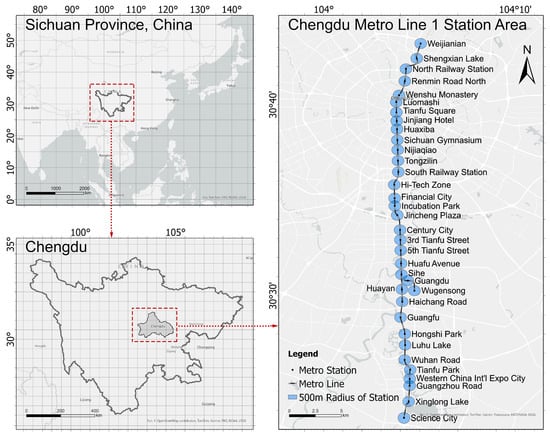
(1) Circle-layer coupling coordination of the horizontal space structure. The central city of Chengdu takes Tianfu Square as the axis and radiates to the surrounding. ① Within a radius of 5 km from the central city, the 10 stations represented by Tianfu Square and Jinjiang Hotel all show high levels of coupling and coordination. The developments of the population, economy, and industry in this area have been highly mature, and a high-quality-coordinated development has been formed between the demand for human activities and the allocation of metro resources. ② In the area outside the radius of 5 km from the central city, the coupling and coordination levels of the station area gradually decrease with increasing distance from the central city. For example, Weijiannian and Shengxian Lake, which are located in the north of the central city, have lower levels of coupling and coordination in the station area, and they are all basically coordinated. ③ Especially in several station areas more than 15 km away from the central city, the coupling coordination levels are moderate and serious, such as in nine station areas located in the south of the central city, including Hongshi Park and Luhu Lake. This area belongs to the Tianfu New District of Chengdu, which was newly approved in 2014. Compared with the traditional central city, although the metro facilities were planned earlier, the population and industrial agglomeration effects of the station area are weak and have an insufficient driving effect on the development of the core area of the station. The advantages of transportation and land resources in the station area have not been fully exerted, and the potential for further improvement is huge.
(2) Multi-center-coupling-coordinated horizontal spatial structure. Except for the station areas within a radius of 5 km of the central city, the coupling and coordination levels of seven station areas, such as the Financial City and the Incubation Park, on the south side of the central city, are good. This area belongs to the Chengdu High-Tech South Zone. According to the Master Plan of the Land and Space of the Chengdu High-Tech South Zone (2021–2035), these seven stations are located in the Central Vitality Zone (CAZ). As a pioneering demonstration area in the fields of scientific and technological innovations, industrial clustering and regional cooperation in the Chengdu CAZ show high levels of development vitality. Especially in the station areas of the Fifth Tianfu Street and Third Tianfu Street, the core functions, such as finance, business, and headquarter offices, are highly concentrated, which is an important reason for the high levels of coupling and coordination in this area.
4.4. Influencing Factors of Coupling Coordination Degrees in Station Areas
After obtaining the CCDs of 35 stations along Chengdu Metro Line 1, the gray relational degree (GRD) between each influencing factor and the CCD was calculated according to gray relational analysis (GRA), and the calculation results are shown in
Table 5. The results show that the GRD between each influencing factor and the CCD is above 0.8, which indicates that each influencing factor is closely related to the CCD. The GRD of M21 is the highest, which is 0.953, followed by L22, M42, M44, M11, and M21. This shows that the degree of the population concentration and the intensity of population activities are the primary factors affecting the levels of coupling and coordination between the people and land in metro station areas. In addition, the level of economic development, the land use, the degree of contact between metro stations and surrounding areas, and the service supports of shopping and catering also have significant impacts on the evaluation results. However, the GRD values of L41, L31, M41, L11, and M31 rank lower, indicating that factors such as the average daily passenger traffic, housing price, proportion of residential land, and number of industrial parks have relatively weak influences on the coupling and coordination levels. However, the GRDs of these factors are all above 0.875, which is at a high level, and the influence on the coupling coordination level is still obvious.
4.5. Future Prediction of Coupling Coordination Degrees in Station Areas
By analyzing historical data and employing the GM(1,1) model, we forecasted the coupling coordination levels of 35 station areas along Chengdu Metro Line 1 for the year 2030 (
Table 6). Compared to the current status in 2024, the coupling coordination levels of 19 station areas will improve, representing 54.3% of the total, surpassing one-half. Notably, stations such as Science City and Xinglong Lake have seen significant improvements, with advancements spanning two levels. These stations are situated within the core area of the Tianfu New District, indicating that the current development policies effectively support regional development. The interactions among the population concentration, economic growth, industrial clustering, and subway resources will be notably strengthened. Furthermore, stations like Third Tianfu Street and Fifth Tianfu Street, located in the Central Activity Zone (CAZ), will achieve the highest coupling coordination levels, demonstrating high-quality coordination. This suggests the formation of a multi-center spatial structure characterized by enhanced coupling coordination. It is important to note, however, that stations in the northern part of the central city, such as Shengxian Lake and Wejianian, will not show significant improvement in their coupling coordination levels, indicating slower coordinated development in this region.
5. Discussion
5.1. Research on the Coordination of the Human–Land Relationship in Metro Station Areas
Based on the evaluation results and characteristics of the coupling and coordination levels of 35 stations along Chengdu Metro Line 1, this paper researches and makes a judgment on the conflict between humans and land in the metro station area, mainly in the following aspects:
(1) The lack of support for urban economic and social activities by metro station areas is mainly reflected in the following aspects: ① Although the coupling and coordination levels of metro station areas in the central city are high, the coverage rate of metro stations to the population and industry in the central city is still insufficient. According to the relevant data published in the “Express Report of Urban Rail Transit Operation Data in November 2023”, published by the Ministry of Communications, the length of the metro line in downtown Chengdu is 258 km, and the density of the metro line network in downtown Chengdu is 0.61 km/km
2. Compared with the highly developed areas of rail transit, such as Tokyo, Japan, there is still a huge gap. Chengdu is the central city in the west of China. In 2020, the resident population of the central city will reach 15.41 million, resulting in a huge metro operation load in the densely populated areas. As an important public transportation system to boost urban economic development and serve urban residents’ travel, the setting of metro stations should be fully integrated with the urban population distribution and industrial planning and layout to maximize its traffic efficiency and enhance social value. ② In the newly developed urban areas, the attraction of the metro station area to the population and industry is still insufficient. Although Chengdu Metro Line 1 has achieved a rapid connection between the central city and the core area of the Tianfu New District, with efficient traffic and convenient resource flow, the coupling and coordination levels of metro station areas located in the core area of the Tianfu New District, such as Science City and Xinglong Lake, are still lower than those of the central city, and the advantages of metro resources have not been fully exploited. For example, at the Science City Station at the end of the metro line (
Figure 6), a large number of companies, enterprises, and service facilities are only concentrated in the new financial valley on the northeast side of the metro station; the industrial layout in the station area is obviously unbalanced and insufficient, and its attraction to the population and economic activities is also insufficient.
(2) Second, the comprehensive development efficiency of the metro station area needs to be improved: ① The development intensity of the metro station area in the central city is not high. Because of the environmental status, ownership of property rights, development costs, and other factors, the conditions and maturity of the complex development around the station area of the central city are insufficient, which limits the leading role of the station area in urban economic and social activities to some extent. ② The regional coordination of metro stations in the new area is weak. Although the development of Chengdu Metro Line 1 around the station area has formed a certain scale, which reflects the gathering of the population, industry, and other factors to a certain extent, the development between regions is unbalanced and insufficient, especially along the southern line, where the population and industry gather slowly, and the coupling and coordination between the station areas are low, so there is no good coordinated development relationship between the demand for human activities and the supply of metro resources. For example, Third Tianfu Street, located in the CAZ District (
Figure 7), has been developed and utilized at a large scale by relying on the industrial layout under the guidance of policies, showing high levels of coupling and coordination. However, the number of public service facilities in the station area is insufficient, and there is huge room for improvement in this respect in the future.
5.2. Optimization and Promotion Strategies of the Human–Land Relationship in Metro Station Areas
In view of the above problems, this paper puts forward the following optimization and promotion strategies to strengthen the coordinated development between the demand for human activities and the supply of metro resources in the station area and promote the coordinated, efficient, and sustainable development of people and land in the station area.
(1) Optimize the layout of the metro network in the downtown area. It is necessary to give priority to strengthening the density of the metro network in the central city, providing more powerful service support for areas with high population and industry concentrations, coordinating basic functions with the goal of meeting public service demands, and promoting high-quality balance and nearby satisfaction. For new urban areas and urban suburbs, it is necessary to focus on the development of key areas to achieve competitive development to ensure the coordination between development needs and resource support and avoid the over-exploitation and waste of resources.
(2) Construct a multi-level urban center system supported by metro stations. As arteries of urban development, metro and urban spatial structures can influence and shape each other. In order to realize the overall spatial layout of “one mountain with two wings” in Chengdu and form a functional structure of “multi-center, network, and group”, we must rely on the construction of metro station areas to promote the development pattern of multi-level urban centers in the central city, new urban areas, and new suburban cities and promote the high-quality development of station areas.
(3) Strengthen the connection of various urban functions in the metro station area. In the future, relying on long-term rail transit network planning, large-scale traffic resources, such as people flow, business flow, and logistics, in the station area will be transformed to a high-energy traffic economy, and industrial areas, business areas, cultural and educational areas, living areas, and transportation hubs will be connected and nested to realize an intensive and efficient production space and an appropriate living space.
(4) Enhance the intensity of the land development in the metro station area. In the future, guided by the development of metros, we should focus on improving the urban spatial layout of the station area, adjusting and optimizing the proportions of production and living ecological spaces, and shaping the dynamic growth pole of the distribution of business centers, residential centers, and industrial centers, thus effectively promoting the overall benefit of the area, reshaping the urban economic geographical space, and realizing the integration of the production and city and the balance between occupation and residence.
6. Conclusions
Taking Chengdu Metro Line 1 as an example, this paper constructs an evaluation indicator system of the coupling and coordination relationships between people and land in the station areas along Chengdu Metro Line 1, quantitatively evaluates the coupling and coordination levels between the human activity demand system and the metro resource supply system in 35 station areas along the line, using the coupling and coordination degree model, and analyzes its spatial distribution characteristics and influencing factors, which provide a new method for the study of the coordinated development of metro station areas.
This research shows that (1) the spatial distribution of the regional coupling coordination levels of 35 stations along Chengdu Metro Line 1 presents a circular structure dominated by the central city. The metro station areas in the central city show high levels of coupling and coordination, while the coupling and coordination levels of metro station areas in areas outside a radius of 5 km from the central city gradually decrease with increasing distance from the central city, and the imbalance degree of the terminal stations is more serious. (2) The coupling coordination level of the station area presents the spatial distribution of the polycentric structure. In addition to the central city, the metro station areas located in the Central Vitality area of the High-Tech South Zone also show high levels of coupling and coordination. (3) The degrees of population concentration and activity intensity, the levels of economic and industrial development, the level of service support, and the degree of contact with the surrounding areas significantly affect the levels of the human–land coupling and coordination in the metro station area.
Through analysis, this paper determines the uncoordinated characteristics among the population growth, economic development, industrial agglomeration, and metro resource supply in the metro station area, which are of practical significance for evaluating the current situation of metro station areas’ construction and development, guiding metro station planning, and formulating metro station area development strategies. According to the disharmony between the people and land in the metro station area, this paper puts forward some improvement strategies, such as optimizing the network layout, building multi-level centers, strengthening functional connections, and enhancing the development intensity, in order to promote the coordinated and adaptive development of the station area and promote the sustainable development of the city.