1. Introduction
Land use and land cover (LULC) change monitoring and assessment have been instrumental in our understanding of environmental research related to biodiversity and ecosystem conservation, land erosion, and desertification, but also for climate change studies, as land use changes have been reported to account for a significant portion of global carbon emissions [
1,
2,
3]. Terrestrial ecosystem carbon storage plays a key role in the global carbon cycle. Increasing the carbon storage of terrestrial ecosystems can reduce the content of CO
2 in the atmosphere. Thus, it is considered one of the most economically feasible and eco-friendly approaches for mitigating the greenhouse effect and climate change [
4,
5], so the importance of LULC is indisputable. LULC investigations are also becoming an essential aspect of the ecological, economic, and environmental management of natural resources [
6,
7,
8].
Remote sensing LULC data are becoming increasingly important. Because of the cost, time, and effort restrictions related to the acquisition of ground LULC information at a sufficient temporal and spatial resolution, satellite remote sensing LULC data are nowadays used as the primary source of information to support the monitoring, assessment, and modeling of landscape changes at the local, regional, and global scales [
9]. Several studies have employed remotely sensed LULC data to assess environmental benefits and investigate spatial patterns of urban carbon metabolism and related ecosystems [
10,
11,
12].
Several types of LULC change modeling have been found in relevant publications. For example, during the period 2005–2012, Patch-Logistic-CA was tested by simulating urban growth in Guangzhou, China [
13]. Dan applied a Logistic-CA-Markov coupled model to the quantitative prediction and spatial simulation of the trend of land use change under three different scenarios [
14]. Yang used an artificial neural network–cellular automata model to simulate land use change [
15]. Luo utilized the conversion of land use and its effect model to simulate land use changes at a high spatial resolution with the spatial consideration of spatial policies, land use appropriateness, and limits to balance land use demand and supply [
16]. And some other researchers have applied future land use simulation models explicitly to simulate the long-term spatial trajectories of multiple LULC changes [
17,
18,
19]. However, Many CA models cannot simulate the detailed patch evolution of multiple land use types [
20]. This research presents a patch-generating land use simulation (PLUS) model, which improves the traditional CA model and achieves a higher simulation accuracy and better results by including new land conversion rule mining strategies and multiple seed growth mechanisms [
21]. Han used the PLUS model to simulate the ecological risk of the landscape in the central mountainous region of Hainan Island, providing good suggestions for the sustainable development of Hainan Island [
22]. Yao explored the development of coal resource-based cities’ spatial structure and function based on the PLUS model [
23]. Chen employed a patch-generating land use simulation (PLUS) model for the multi-scenario simulation of urban agglomerations [
24]. Reasonable suggestions were provided for the development of cities. Xie compared the LULC simulation accuracy of the conventional CA-Markov model with the PLUS model in the same region [
25]. The results fully confirm that the PLUS model can perform an excellent spatial simulation based on land use data and driving factors.
As a result, extensive research can prove that the PLUS model is better than other models in terms of the simulation accuracy and similarity of landscape pattern metrics to the natural landscape [
20,
26,
27].
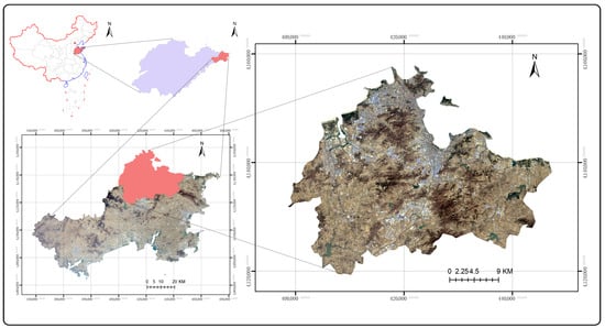
The RUA (Rapid Urbanization Area) is located in the east of Weihai City, on the coast of the yellow sea, China. It became one of the first open coastal regions in China in 1984; the RUA has undergone rapid development since then. In 2003, Weihai was awarded the UN-Habitat Award, the highest global award in the field of habitats, for its “outstanding contribution to the improvement of habitat and urban environment”. Weihai has twice won the United Nations “Dubai International Award for Best Practices” and is also the first “National Sanitary City”, the first provincial “Garden City”, the “National Garden City” etc., in China [
28]. The ecological environment quality of Weihai has been highly praised [
29]. China is the world’s largest developing country and carbon emitter [
30]. As the most critical region of Weihai, the RUA is very representative for use in studies on Weihai. As a result, this study’s main objectives are to identify LULC change patterns in the RUA, Weihai City, over 20 years, according to five-time points, 2000, 2005, 2010, and 2020, using GIS and RS techniques. This project aims to collect data that will aid in filling these research gaps. It also seeks to forecast trends and the size of future changes. Such forecasts will help alert scientists to potential future threats and assist decision-makers in planning and selecting development plans.
Additionally, under China’s carbon neutrality and carbon peak goals, as a city with prominent ecological advantages, studying Weihai’s land use and carbon storage changes will help explore low-carbon development paths and provide valuable insights for other cities. And as the core district of Weihai, Huancui District has diverse land uses. Studying the impact of land use changes on the carbon storage in this area can better guide the balance between development and ecological protection.
Here, we propose an integrated framework based on the PLUS model and Integrated Valuation of Ecosystem Service and Tradeoffs (InVEST) model. This can provide a better understanding of the land use changes and changes in carbon storage in the study area. China is the world’s largest developing country and carbon emitter [
30]. At the same time, China is committed to achieving “carbon neutrality”. Thus, a quantitative assessment of the ecosystem carbon storage and future changes in carbon storage could help policymakers make more scientifically based decisions regarding strategies for economic development as well as improve the value of ecosystem services.
4. Discussion
In Weihai City, the air quality meets the national class II standard, the potable and coastal water quality remains good, and the soil quality also meets class II standards (GB15618-1995). The city’s Eco-environmental Index of 58 qualifies it as a national ecological civilization demonstration city, attributed in part to steady woodland growth [
50].
Remote sensing (RS) and GIS are increasingly used in land use and land cover (LULC) monitoring, especially in protected areas, as they provide more efficient and accurate monitoring capabilities [
51,
52]. Given society’s focus on environmental preservation, this study employs a long-term LULC analysis for the RUA [
53].
The relationship between humans and the land reflects an interdependent and interactive connection between humans and nature. Through field surveys, it was found that land use change in Weihai City is difficult for communities or individuals to directly perceive, as it primarily involves the conversion of cultivated land. This issue is a latent one and can be more easily identified from a macro perspective. Therefore, it is necessary to strengthen policy guidance.
This study examined 20 years of LULC changes in the RUA, forecasting future impacts. The results show substantial urban expansion, from 128.84 km² (13.20%) in 2000 to 258.47 km² (26.49%) in 2020, mainly at the expense of cultivated land, which declined by 218.35 km² (−22.36%). Although policies aimed at protecting cultivated land exist, they were not fully effective, and traditional monitoring methods were limited [
49]. The use of GIS and RS in this study addresses these monitoring gaps.
Woodland and bare soil increased slightly by 53.07 km² (5.44%) and 40.99 km² (4.2%), respectively, while water bodies decreased marginally by 5.44 km² (−0.56%) due to reclamation. The carbon storage in the study area declined by 14.92 × 10⁴ t between 2000 and 2020, largely due to urban expansion and cultivated land reduction. Future scenarios with the better conservation of cultivated land show greater carbon storage potential.
Overall, the RUA’s LULC changes from 2000 to 2020 were policy-driven, with stable woodland growth supporting environmental benefits. However, the significant loss of cultivated land poses potential ecological and socio-economic challenges. These results align with those of Wang et al. [
54], who identified rapid economic growth, urbanization, and population increases as key drivers of land use change.
5. Conclusions
To address social, economic, and environmental challenges, understanding spatio-temporal changes in land use and land cover (LULC) is essential, especially in dynamic coastal zones, where land and sea interactions are intense. Prior studies, such as those by Awange and Zheng [
55,
56], highlight the significance of monitoring coastal LULC changes and vulnerabilities.
In this paper, the supervised classification method of the neural net can generate an accurate and reliable LULC classification map in the RUA. At the same time, we analyzed the change in the carbon stock in the RUA. The LULC classified maps have an overall accuracy of 90.65% to 94.72%. In this study, the trend, size, and rate of LULC change from 2000 to 2020 were quantified over approximately 976 km2, while the LULC was projected for 2030. The findings indicate that urbanization and agricultural activities are at the root of most of the changes observed in the RUA. Under the current circumstances, the reduction rate of the cultivated areas has decreased, but the cultivated areas will be further reduced according to conservative predictions. And, because of the loss of cultivated areas, urban areas are expected to grow even more. This will lead to a further decrease in the land carbon storage in the RUA. Thus, a drastic decline in cultivated areas would result in many socio-economic and environmental issues. In the last LULC prediction in the RUA, the reduction in the cultivated areas exceeded expectations. As a result, it is time to implement more stringent protection measures and more effective monitoring methods for cultivated areas. This led us to suggest five recommendations for sustainable development:
(1) Properly protecting cultivated land, prioritizing the development of arable land (especially basic farmland) and woodlands.
(2) The intensive use of construction land. Based on the necessary land demand for economic development, the need for construction land should be decreased as much as possible. The scale of new construction land should be strictly controlled. All construction land should make full use of the existing stock of land, mainly by internal tapping, intensive use, and improving the land use efficiency.
(3) The expansion of construction land should make full use of idle land and try to occupy poor land. The occupation of arable land and forest land should mainly be controlled.
(4) The scientific adjustment of village land. Rural areas with low land use efficiency should be consolidated to improve the rural construction land utilization rate.
(5) The application of satellite remote sensing, UAV remote sensing, and other technologies in land use monitoring should be strengthened.
These measures will further optimize the land use pattern in the RUA and increase carbon storage. At the same time, they will strengthen the long-term cyclical sustainability of the RUA’s economy and ecology, rather than focusing on short-term benefits.
The findings of this study can serve as a solid platform for further investigation and help the government make integrated planning and management decisions in the RUA. Further research on urban planning and environmental factors in the RUA are a necessity.