
In late December, China approved the world’s largest hydropower project to begin construction, citing the economic benefits and need to shift to renewable energy sources. However, opponents argue that frequent natural hazards in the region create risk for the project and surrounding Tibetan communities, as well as for the downstream countries of India and Bangladesh.
The Motuo Hydropower Project is central to China’s goal of reaching a carbon emissions peak by 2030. Though China is still the world’s largest greenhouse gas emitter, it also leads in renewable energy project development, investing $890 billion in hydropower, solar and wind energy in 2023 alone as it rapidly shifts away from coal power. The Motuo Project is expected to generate three times as much energy as the Three Gorges Dam located on the Yangtze River, which currently generates the most power of any hydroelectric project in the world, supplying electricity for 70 to 80 million Chinese homes annually.
According to Philippe Benoit, the managing director at Global Infrastructure Advisory Services 2050 and a former adjunct senior research scholar with Columbia’s Center on Global Energy Policy, this energy is especially important for China which, like other developing nations, “is projected to see increases in energy demand in addition to [seeking to meet] their decarbonization target.”
China also claims the reservoir behind the Motuo station will help alleviate water shortages on the Tibetan Plateau, where communities heavily reliant on glacier meltwater expect to face water scarcity due to climate change and glacier retreat.
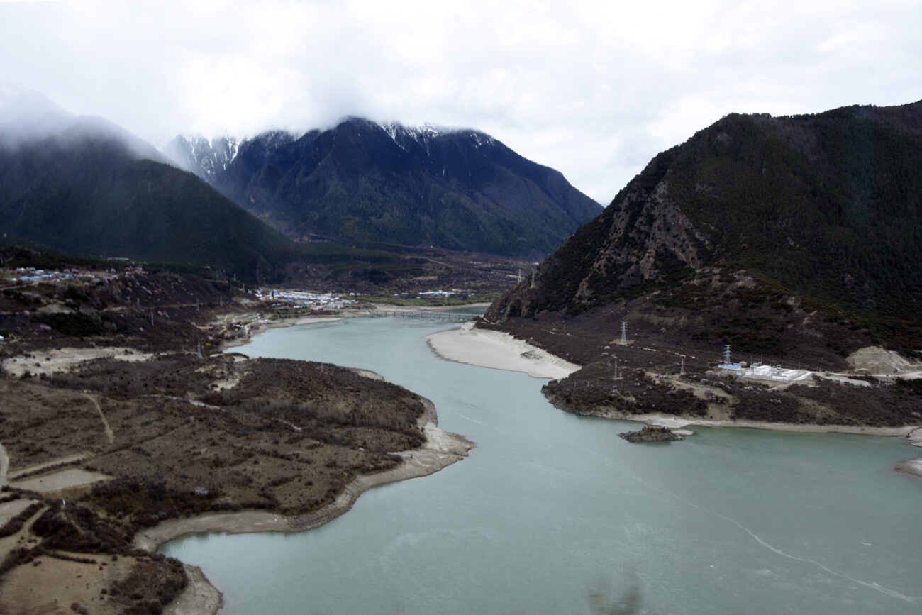
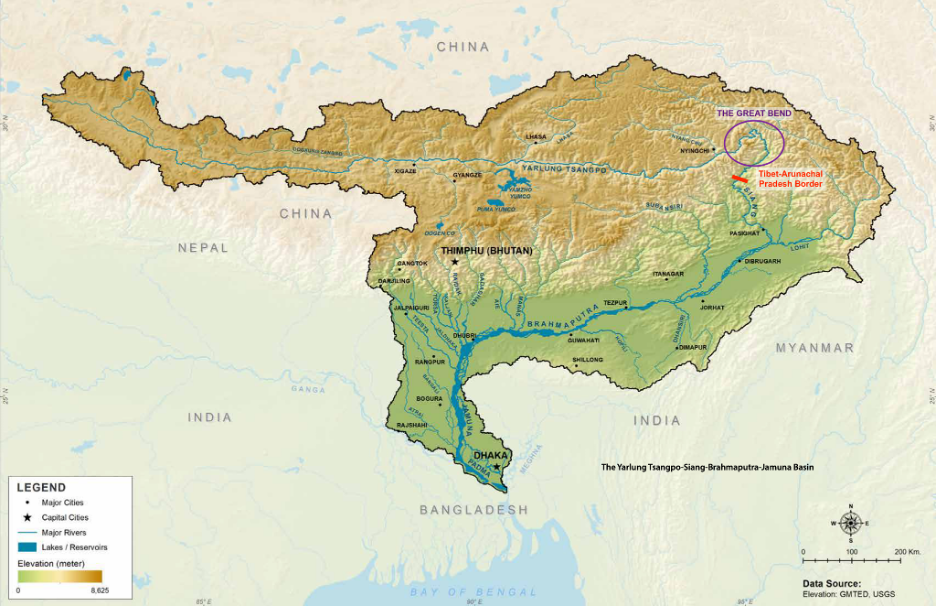
However, the project is controversial due to its location. The station is expected to be built on the Great Bend, a horseshoe-shaped section of the world’s deepest land canyon, known as the Yarlung Tsangpo Grand Canyon in Tibet. Located on the Tibetan Plateau just north of the border between China and India, the canyon is three times deeper and 37 miles longer than the U.S. Grand Canyon. It was formed by tectonic interactions between the Indian and Eurasian plates, but these interactions and climate change now threaten the existence of a hydropower project on the river.

As glaciers in the basin shrink in response to climate change, landslides are occurring more frequently along the river. In March 2021, glacier collapse led to a massive landslide with an estimated volume of 100 million tonnes of rock and ice (equivalent to the mass of 302 Empire State Buildings). The debris blocked the Yarlung Tsangpo River just above the Great Bend and caused water levels to rise over 10 meters, or more than three stories. In October 2018, debris from a string of glacial landslides in the basin temporarily blocked the river and flooded the valley. In both situations, urgent evacuations prevented deaths, but the floods still damaged infrastructure.
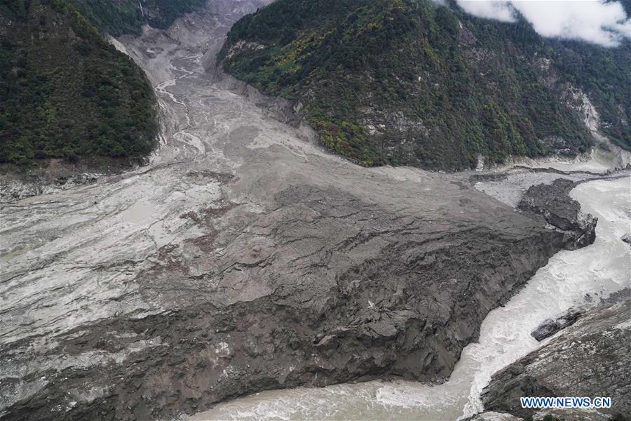
These incidents have fueled concerns that future landslides could create waves that would breach the new dam and lead to devastating effects downstream if concrete debris, landslide material and large amounts of reservoir water flooded down the canyon. Glacier melt in the region is increasing the frequency of these landslides, putting the project at significant risk even if it were successfully built.
Beyond the natural hazards, the construction of this dam and the resulting reservoir are likely to lead to flooding and the displacement of Tibetan people and entire towns, though China has not released these estimates yet. In an interview with GlacierHub, Bryan Tilt, a professor of anthropology at Oregon State University who studies Chinese dams and development, highlighted that resettlement for infrastructure projects is “a contentious social and political issue in China today.” Tilt elaborated, saying, “When you add the fact that this is an ethnically Tibetan area and there’s already political tensions there, it has the potential for increased conflict.”

The smaller Three Gorges Dam displaced 1.4 million people, though estimates vary, and the Chinese government has resettled thousands of Tibetans to construct the Gangtuo Dam, known in Tibetan as the Kamtok Dam, on the Jinsha River, some 1000 kilometers to the northeast of Yarlung Tsangpo. In early 2024, villagers and Buddhist monks protested over the planned Gangtuo (Kamtok) reservoir, which is expected to flood villages and sacred monasteries, including the 700-year-old Wontoe Monastery, which contains rare Buddhist murals. Authorities swiftly cracked down, beating and arresting protestors, though many Tibetan people and organizations still resist these hydropower projects as a violation of their autonomy.
In addition to domestic conflict, this dam would be constructed on a transboundary watershed known for its tense border relations, just upstream of the Indian state of Arunachal Pradesh where the river is known as the Siang or Dihang. Further south, the river is known as the Brahmaputra in most regions of India. Eventually the water body flows into Bangladesh as the Jamuna River. Officials in both India and Bangladesh also disapprove of the authorized Motuo Hydropower Project, citing concerns about water supply and water data sharing issues with China.
In response to the Motuo Hydropower Project, India threatened to build a dam on the Brahmaputra. “This happens a lot when you’ve got a transboundary river and one country builds a dam; it sort of spurs competition,” Tilt explained. India claims that this dam would help protect their water supply and economy, but it could further put the Jamuna’s water supply in Bangladesh at risk.
The approval of the Motuo Hydropower Project sparks larger questions about how world nations navigate addressing climate change and building renewable energy projects while mitigating the risks to local communities.
“From a climate change perspective, this is what we want China to do, right? We want them to shift out of coal into a cleaner source, and hydropower’s a cleaner source,” Benoit explained. “But you have to find the right balance because the local populations are going to be disproportionately affected,” he added.
As the Motuo Hydropower Project advances with little acknowledgement of input from local communities and downstream nations, the concerns about natural hazards, displacement and water supply remain unresolved.
Writer’s note: The transboundary river on which the Motuo Hydropower Project is approved to be constructed is known as the Yarlung Tsangpo in Tibet, the Siang/Dihang in the disputed state of Arunachal Pradesh, the Brahmaputra in India, and the Jamuna in Bangladesh. For this article, all names were used depending on which part of the river was being discussed.
Jenna Travers is a longtime writer for GlacierHub and is also enrolled in Oregon State University’s Water Conflict Management and Transformation Graduate Program. This post is the first in a series covering glaciers and water conflicts for her capstone project.
Source link
Jenna Travers news.climate.columbia.edu