1. Introduction
Remote sensing technologies have profoundly changed our ability to collect information about the Earth’s surface, allowing for the monitoring and classification of land cover and land use in a variety of scenarios. A combination of techniques, along with advanced classification and analytical tools, have proven to be indispensable in monitoring these dynamic environments. Coastal and riverine systems are constantly influenced by anthropogenic and naturogenic activities, necessitating robust methodologies to detect and analyze their changes over time. Therefore, multitemporal high-resolution datasets have considerably increased the possibility for urban land cover classification, ecological land mapping, and overall sea and land monitoring. This introduction provides a detailed summary of recent research initiatives that investigate the changes in coastlines and riverbeds with different approaches to improve the precision and resilience of change detection.
Zoran and Anderson [
1] studied the Romanian Black Sea’s coastal zone to assess transformations caused by nutrient and pollutant loads from rivers, industrial wastewater, and open-water dumping. They utilized multi-sensor satellite data spanning 1975 to 2003 and applied spectral mixture analysis and classification techniques to model land-use changes and sedimentation dynamics, offering critical insights for sustainable land-use planning. Similarly, Kuleli [
2] analyzed shoreline changes in the Cukurova Delta on Turkey’s Mediterranean coast from 1972 to 2002. Techniques such as edge detection, band ratioing, and the Digital Shoreline Analysis System (DSAS) were applied to multi-temporal Landsat images to measure accretion and erosion rates. These methods quantify withdrawal rates exceeding 24.5 m/year, driven by sediment transport and river discharge. In the deltaic zones of Istiaia, Greece, Vassilakis, and Papadopoulou-Vrynioti [
3] used high-resolution aerial photographs and real-time GPS surveys to quantify coastal erosion and accretion. By incorporating geo-statistical analysis in GIS, they accurately delineated retreat and extension rates, demonstrating the utility of combining high-resolution data with geo-statistical modeling for coastal management. Focusing on the uncertainties of shoreline detection, Dewi et al. [
4] employed fuzzy c-means classification (FCM) to monitor shoreline changes in Java, Indonesia, from 1994 to 2015. Their innovative method combined crisp and fuzzy approaches to address positional and methodological uncertainties, achieving high classification accuracy, more specifically a 0.93 kappa value on average for classified images from 1994 to 2015, and reliable change detection.
Xu [
5] adopted a multi-temporal analysis approach using Landsat data from 1986 to 2015 to monitor coastline dynamics in Texas, USA. Through annual land-water mapping and linear regression modeling, the study quantified a retreat rate of 0.154 km
2/year, linking these changes to sea-level rise and hurricane activity. In India, Misra and Ramakrishnan [
6] used Support Vector Regression (SVR) to generate Satellite-Derived Bathymetry (SDB) data for assessing geomorphological changes in Puducherry. This machine learning technique, combined with GIS-based validation methods, effectively mapped accretion and erosion patterns, further enhancing coastal monitoring capabilities. Michałowska and Głowienka [
7] analyzed the Baltic Sea coastline’s long-term dynamics using aerial orthophotos spanning 65 years. Their use of historic and modern datasets with GIS analysis revealed periodic erosion and accretion trends influenced by storm events, emphasizing the importance of long-term monitoring. Zoysa et al. [
8] investigated shoreline changes along Sri Lanka’s Oluvil coastline from 1991 to 2021. By integrating Landsat imagery with GIS and the DSAS tool, the study quantified accretion and erosion rates near the harbor. Their analysis demonstrated the impacts of harbor construction and highlighted the value of transect-based analysis for detecting spatial variability in coastal changes.
In Greece, Nikolakopoulos et al. [
9] examined the Alfios River’s morphological changes from 1977 to 2000. Using multi-temporal Landsat and ASTER imagery, they implemented Principal Component Analysis (PCA) to offset the data from fourteen bands into three with the major volume of information and GIS techniques to map drainage network transformations, identifying significant erosion, reduced meandering, and channel straightening caused by dam construction and gravel extraction. This methodological framework highlights the effectiveness of integrating PCA with GIS for river network monitoring. Li and Damen [
10] employed multi-temporal Landsat and SPOT imagery alongside topographic data to detect coastline changes in China’s Pearl River Estuary. Their methodology combined sedimentation and land reclamation mapping with GIS tools, revealing narrowing river channels and heightened flood risks due to rapid urbanization and industrialization. The application of deep learning in remote sensing was demonstrated by Feng et al. [
11], who developed a multi-branch convolutional neural network (MBCNN) for coastal land cover classification in the Yellow River Delta, China. Their approach, achieving 93.78% accuracy, leveraging multi-temporal and multi-sensor Sentinel data, improved performance by 6.85% and 3.24%, respectively. The fusion module further enhanced accuracy by about 2% over feature stacking. This approach underscores the potential of deep learning for complex coastal environments. Chen et al. [
12] introduced the EMID method to extract river networks using multi-temporal imagery and path-tracking optimization. This two-stage approach employed Random Forest models for water surface mapping and hydrological connectivity analysis, significantly improving river network accuracy. Patel et al. [
13] employed the Digital Shoreline Analysis System (DSAS) and Landsat imagery from 1978 to 2018 to monitor alarming shoreline migration near the Mahi River estuary, India. Their methodology integrated NDWI-based shoreline delineation and transect-based displacement analysis to predict future shoreline changes.
More recently, El-Masry et al. [
14] investigated multi-decadal coastal change detection along the Mediterranean coast of Egypt, revealing a 47.33 km
2 (4.13%) expansion in agricultural land and a 73.13 km
2 (6.24%) reduction in bare soil area over three decades. They also reported an increase in built-up areas by 20.51 km
2 (1.77%) between 2010 and 2020, highlighting the shift toward tourism and urban development in the region. Similarly, Gomes et al. [
15] assessed the use of satellite-derived shorelines and bathymetry for coastal change monitoring in Spain, achieving high horizontal accuracy (RMSE < pixel size) with errors of 5.0 m for Sentinel-2 and 18.8 m for Landsat 5 imagery. Their study demonstrated the capability of satellite data to detect coastal changes across different spatial and temporal scales, though bathymetric assessments remain limited without supplementary in situ data.
Further studies have focused on high-risk coastal regions affected by erosion and accretion dynamics. Kundu and Mandal [
16] analyzed shoreline changes in the Sundarban Delta using multi-temporal Landsat imagery, finding that over 80% of transects in the southern parts of the studied islands experienced gradual erosion. The maximum shoreline displacement was recorded at 2715 m between 1975 and 2020, with erosion rates reaching up to 168.2 m/year. Additionally, Bar et al. [
17] examined coastal dynamics along India’s eastern coast using optical and SAR imagery, reporting annual erosion rates ranging from 0.62 m to 2.60 m, while accretion rates varied from 0.02 m to 5.99 m. They projected significant shoreline changes, with certain areas expected to retreat by up to 67.49 m over the next 15 years.
In the subsequent sections, we present an analytical overview of our study.
Section 2 outlines the study area, and the materials utilized, while
Section 3 elaborates on the steps applied to aerial and satellite data for image registration.
Section 4 details the methodology and results in coastline change detection.
Section 5 examines changes in the two main rivers, Charadros and Selemnos. Finally, in
Section 6, we discuss the overall results of the study, address possible imperfections and their underlying causes, and propose improvements for future research.
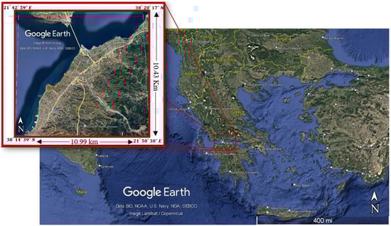
Building on a range of advanced methodologies, this study focuses on detecting coastline and riverine changes in the broader area of Patras, Greece. By leveraging multi-temporal, high-resolution satellite imagery and analytical techniques, we aim to quantify the shoreline retreat, river morphological changes, and potential environmental drivers influencing these transformations. Specifically, our analysis compares historical aerial and satellite imagery from 1945 and 2011 to assess long-term coastal erosion, riverbed modifications, and land-use changes. The findings provide insights into the geomorphological evolution of the region, offering valuable data for coastal management, urban planning, and environmental monitoring. This work contributes to improving change detection accuracy through methodological enhancements, such as refined image processing and classification techniques. The following section outlines the study area and the datasets used in this analysis.
3. Registration
As mentioned earlier, the panchromatic band of the WorldView-2 satellite with a resolution of 0.4 m, coastal and NIR2 bands with a resolution 1.6 m and an archive aerial photograph from the Royal Air Force (RAF) were used (
Figure 3). Since these two data sources do not share the same resolution, a transformation was necessary to correct potential translation, rotation, and scaling distortions. This step ensures that the characteristics from the satellite bands can be accurately assigned to the corresponding pixels in the aerial photograph.
The registration process was performed using the mutual information method. Specifically, an affine transformation was applied to both datasets after correlating regions of overlap between the images. The registration procedure utilized MATLAB 2022b’s “cpselect” toolbox [
18]. Using “cpselect,” regions of mutual information were manually identified and used as inputs for the algorithm in the form of six control points, which remained permanent over time. These control points are illustrated in
Figure 3a,b.
To better understand the process of registration, consider two images of the same planar object captured from different viewpoints. Let and be corresponding points in the two images. The coordinates of can be described in terms of the coordinates of using an affine transformation as follows:
Here,
A is a non-singular
matrix, and
t is a two-dimensional vector. A planar affine transformation is defined by six parameters, which account for translation, rotation, scaling, and shearing [
19]. Representing this transformation in terms of the image coordinates of the points, (1) can be written as
According to the MATLAB help center, for affine transformation, the following is obtained:
where ; are the transformed coordinates;
are the transformation coefficients for scaling (), rotation (), and shearing (); and are transformation coefficients for translation (, ).
After finding the control points that are more suitable, we used the cp2tform function in order to calculate
matrix as shown in
Figure 2.
Table 1 illustrates the different affine transformations matrices, i.e., translation, scale, shear, and rotation [
20].
To present what transformations have been applied in our case, we first have to calculate the coefficients.
Looking at Formula (5), we see that the coefficients
are
If we consider that the shearing transformation matrix is
, we have
Knowing the coefficients of
, we are able to solve the system defined from Equations (6)–(11). This procedure gives us the ability to understand what transformations have taken place and by extension what is really happening behind the MATLAB functions to make the registration happen. The results of the solved system are given in
Table 2:
In our case,
Table 2 gives us very important information regarding the transformations that were applied. We understand that for the moving image, we have 2461 pixels left offset at the x-axis and 9.81 pixels down at the y-axis. We have almost a uniform scale reduction of the recovered image at about 0.85 and at a clock-wise rotation of about 6.73 degrees with almost no shearing at the x-axis.
The transformation factors were calculated using the VHR panchromatic image and subsequently applied to all layers of the aerial RGB image. This process resulted in the final registered archive aerial image of Patras, as shown in
Figure 3c.
6. Discussion and Conclusions
To summarize, the results of this study highlight the significant geomorphological changes in the broader area of Patras over a period of 66 years. By utilizing historical aerial imagery from 1945 and high-resolution satellite data from 2011, we were able to quantify changes in both the coastal zone and the riverbeds of the Charadros and Selemnos rivers. The applied methodologies, including image registration, feature extraction, supervised classification, and NDWI-based water body delineation, proved to be effective in capturing and analyzing these changes.
6.1. Coastal Zone Changes
The coastline analysis revealed substantial modifications, particularly due to human activities such as the construction of the Rio-Antirio Bridge, breakwaters, and other modern additions such as the harbor at the city center and 2 Km northeast (Pelekaneika) of Patras, which consist of the docks for yachts and recreational areas. The study identified a net gain of approximately 0.5235 km2 of new land, primarily in the harbor expansion and protective coastal structures. On the contrary, approximately 0.1375 km2 of land has been lost due to natural coastal erosion and other human interventions due to urbanization. The comparison of our methodology with Google Earth Pro measurements demonstrated high accuracy, confirming the reliability of the NDWI-based approach in detecting coastal variations.
6.2. Riverbed Transformations
The river classification results indicate drastic reductions in riverbed widths, particularly in the deltas of Charadros and Selemnos. The Charadros River’s main body shrank from 388 m in 1945 to just 88 m in 2011, marking a 77.3% reduction, while its delta width decreased by 94.6%. Similarly, the Selemnos River experienced a 56.1% contraction in its main body and a 97.9% reduction at its delta. These changes are likely attributed to sediment deposition, urbanization, and the construction of flood control infrastructure. Despite the high classification accuracy achieved, challenges arose in distinguishing riverbeds from the surrounding land due to dry river conditions and vegetation cover, which obscured river features mainly in the 2011 imagery.
6.3. Comparison with Previous Studies
Among the most fascinating studies that align closely with our research are those by Feng et al. [
11], Dewi et al. [
4], Kuleli [
2], Nikolakopoulos et al. [
9], and Kundu and Mandal [
16], each offering unique insights into coastal and riverine dynamics. Feng et al. [
11] employed deep learning with a multi-branch convolutional neural network (MBCNN) for coastline classification in China’s Yellow River Delta, achieving a similar accuracy (93.78%), while our study also integrates machine learning via SVM, achieving 92.6% and 92.5% accuracy at new and old imagery, respectively. Incorporating deep learning could further enhance classification precision, especially in complex environments. Similarly, Dewi et al. [
4] tackled shoreline uncertainty using fuzzy c-means classification, addressing the challenges of positional inaccuracies in Java, Indonesia. Our approach of image registration and NDWI-based water delineation serves a similar purpose but could benefit from uncertainty modeling to refine boundary detection. Kuleli [
2] conducted a long-term assessment of shoreline retreat in Turkey’s Cukurova Delta, using edge detection and band ratioing to quantify erosion rates. In ours, this concept is advanced by incorporating pixel-wise classification and feature extraction, offering a finer-scale analysis. Nikolakopoulos et al. [
9] analyzed river network transformations in the Greek river of Alfios using PCA and GIS-based mapping, highlighting human-induced morphological changes. Our research follows a similar trajectory, but with a greater emphasis on texture-based classification for detecting riverbed shrinkage. Finally, Kundu and Mandal [
16] examined the Sundarban Delta’s rapid erosion, predicting future shoreline retreat through statistical modeling. While our study focuses on past changes, integrating predictive modeling could enhance its applicability for future coastal and riverine management. Overall, our methodology builds upon these innovative approaches while offering a unique contribution through the integration of high-resolution historical and modern imagery.
6.4. Methodological Strengths and Limitations
The integration of archive aerial imagery with modern high-resolution satellite data provided valuable insights into long-term landscape changes, allowing for a comprehensive analysis of coastal and riverbed modifications. The use of image registration techniques ensured the accurate alignment of datasets, minimizing spatial discrepancies between the 1945 and 2011 images. Additionally, GLCM-based feature extraction effectively captured texture variations, while the SVM classifier provided robust discrimination between river and non-river areas, achieving high classification accuracy. These methodological choices enabled a detailed assessment of geomorphological transformations, supporting reliable change detection.
However, certain limitations were encountered. One major challenge was the difficulty in detecting dry riverbeds due to vegetative overgrowth, particularly in the 2011 imagery. The dense vegetation obscured river features, leading to potential misclassification. Additionally, the visual similarity between dry riverbeds and the surrounding land posed challenges for classification, sometimes causing areas of bare land to be falsely identified as river pixels. Another significant constraint was the high computational cost of processing high-resolution data. To manage this, we had to reduce the spatial resolution of processed images, which, while improving efficiency, may have led to a loss of fine details.
6.5. Environmental Implications and Urban Planning Considerations
The detected changes reveal both coastal retreat and land expansion, emphasizing the dynamic nature of the study area. While erosion has reduced river widths and caused shoreline retreat in certain areas, sediment deposition—especially near the Charadros River delta—has led to the formation of new land. Notably, the area known today as Plaz Patras did not exist in 1945, highlighting the extent of coastal transformation over time. These changes have significant environmental implications, affecting sediment transport, ecosystem dynamics, and flood risks. From an urban planning perspective, the newly formed land presents opportunities for controlled development, but careful management is essential to prevent instability or unintended environmental consequences. Sustainable planning and conservation strategies should balance land use with ecological preservation to ensure long-term resilience.
Taking into consideration the results of our research, we could suggest some possible practical applications for coastal protection, flood risk management, and sustainable urban expansion. The narrowing of riverbeds, especially in Charadros and Selemnos, increases flood risks, requiring dredging or drainage improvements. Identifying erosion-prone zones can guide shoreline reinforcement and infrastructure planning, while newly formed land, like Plaz Patras, requires careful zoning policies to prevent environmental instability.
In conclusion, this study successfully quantified land cover changes in Patras’ coastline and riverine systems using a combination of remote sensing techniques and machine-learning-based classification. The findings emphasize the profound impact of anthropogenic interventions on coastal expansion and river morphology. Such insights are crucial for urban planning, coastal management, and environmental monitoring.
Future improvements could involve integrating additional spectral indices, deep learning approaches that would help to better distinguish similar land covers, or the incorporation of hydrological models for an in-depth understanding of the changes that took place through time and the enhancement of riverbed classification accuracy. Additionally, we recommend the incorporation of additional temporal datasets to analyze trends beyond 2011 and the development of hybrid models combining statistical and machine learning approaches for improved classification accuracy. Nevertheless, the accuracy of the method would be improved if we had other scenes with high-resolution data, which was not possible at this stage, and simultaneously, there are no high-resolution data before 1995. By advancing these methodologies, we can better understand and mitigate the environmental consequences of landscape alterations, ultimately contributing to more sustainable coastline and riverine management practices.