Over the past 50 years, the rapid pace of industrialization has led to significant economic growth in northwestern China, resulting in stable development across various industries [1]. However, this rapid development has also brought about serious environmental issues, such as river discontinuity, lake desiccation, land degradation, and other problems related to regional development [2]. Addressing these critical ecological issues is essential for sustainable development, making the identification of the ecological security pattern (ESP) and the formulation of reasonable recommendations crucial [3].
The study of the ESP began in the 1950s, focusing primarily on biodiversity conservation [4]. In the 1990s, researchers expanded their approach to include the structure and processes of ecosystems from a landscape ecology perspective, leading to the development of the ESP concept [5]. The ESP serves as a vital tool for regional ecological security by protecting key ecological processes through the conservation of significant landscape components [6]. By examining the interaction between landscape ecology and ecological processes, the construction and optimization of the ESP can effectively prevent inefficient regional conservation, manage conflicts between ecological protection and economic development, and safeguard the ecosystem services necessary for a healthy environment [7].
Current ESP research primarily focuses on developing theoretical frameworks, selecting methods for identifying ecological security components, and enhancing evaluation indicator systems [8]. The research framework of “identifying ecological sources, constructing resistance surfaces, and extracting corridors” has become the standard for regional ESP construction [9]. Ecological sources are large-scale patches that perform critical functions for the region and are essential for maintaining ecosystem functions. Identifying these sources involves evaluating ecological suitability, importance, sensitivity, and connectivity [10]. Among these methods, evaluating ecological importance based on multiple ecosystem services is the most commonly used approach for selecting ecological sources [11]. The InVEST model, known for its integrated valuation of ecosystem services and trade-offs, is widely used due to its independent testability and open-source nature [12]. Identifying ecological corridors through resistance surfaces typically involves assigning land cover values and incorporating indicators such as night light intensity to refine the resistance surface [13]. Most researchers construct resistance surfaces based on expert experience to assign values to different land use types [14]. However, this approach overlooks spatial variations within the same land use type and fails to objectively and scientifically describe barriers to species movement. Common models for determining ecological corridors include the minimum cumulative resistance (MCR) model [15], the least-cost path (LCP) [16], and the circuit theory [17]. Although the MCR model is widely used for simulating ecological corridors, it does not account for corridor width or clearly identify key nodes within the corridors [18]. In 2007, the circuit theory was introduced to the study of gene flow in heterogeneous landscapes from a physical perspective [19]. The circuit theory likens ecological flows to electrical currents due to their random walk characteristics, making it useful for predicting movement patterns in complex landscapes, assessing habitat patch isolation, and identifying significant landscape features. Today, the circuit theory is extensively applied in ecological protection analysis, particularly for determining priority areas for endangered species conservation [20,21]. By simulating the movement and gene flow of wildlife based on the random walk behavior of electrons in a circuit, the circuit theory aids in achieving ecological connectivity and protection [22]. Combining the circuit theory with the LCP model has addressed the limitations of earlier methods and is increasingly employed for quantitative studies of ecological corridors, nodes, and barriers [23,24].
In recent decades, ESP construction has become increasingly common in studies of cities, urban agglomerations, and watersheds, garnering significant research attention [25]. These studies have constructed urban ecological security patterns in different regions from different perspectives [26]. In urban agglomerations globally, various elements interact with each other, and the ecological security pattern of coupled multiple elements and structures develops in representative regions [27,28,29]. The ecological security pattern, with the geographic unit as the research object, is one of the research hotspots, which is represented by watershed studies [30,31,32]. However, research on the ESP in ecologically sensitive and fragile areas remains limited due to adverse climatic conditions and complex topography, particularly in arid inland regions and high-altitude cold areas [33]. The impact of severe climate change and human activities on dryland ecosystems has created numerous ecological security challenges that require more focus from both governments and researchers [34].
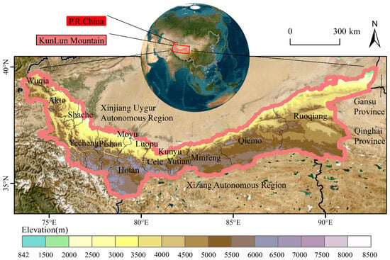
The Kunlun Mountains, located in northwestern China, with a cold and dry climate and a fragile ecological environment, serve as a critical ecological security protection area for both China and Central Asia [35,36]. This study has two main objectives: (1) to determine ecological corridors and current densities using the MCR method, and to identify ecological nodes and barriers based on current densities and (2) to combine the ecological security pattern based on functional classes with species-appropriate zones to form a comprehensive ecological security pattern in the Kunlun Mountains. The development of China’s northwest region highlights a conflict between fragile ecological environments and strong development pressures. This study focuses on the Kunlun Mountains and aims to resolve the conflict by constructing an ESP to provide the following references for the development of the Kunlun Mountain region: (1) Assisting the northern foot of the Kunlun Mountains in integrating into the “Belt and Road” economic belt construction in southern Xinjiang, using the development of the Kashgar port to drive the development of the urban agglomeration at the northern foot of the Kunlun Mountains. (2) Improving the construction of the Kunlun Mountain National Geopark to promote the coordinated development of regional tourism and ecological protection. This study aimed to tackle the effects of climate change and human activities on the region’s natural environment, offering valuable insights for regional development.
Source link
Jianglong Yuan www.mdpi.com


