
Back in April, scientists read the tea leaves — or, more accurately, heaps of data — and predicted an above-average hurricane season over the summer and autumn, with nine or 10 named storms, four of which could grow to major strength. Yet hurricane season ended Sunday without even one of them making landfall in the United States for the first time in a decade. That was extraordinary in a good way, but the season was also extraordinary in many bad ways.
So how did the U.S., which was walloped by Hurricane Helene and four other tropical cyclones last year, escape disaster even as the Caribbean suffered mightily from Melissa in September?
Secure · Tax deductible · Takes 45 Seconds
Secure · Tax deductible · Takes 45 Seconds
First off, forecasters could make those predictions in April by considering a few factors. Hurricanes are atmospheric engines fueled by warm water, and the Atlantic Ocean has been downright hot of late, meaning more juice for bigger storms. “The main consideration going into the season was just very, very warm ocean temperatures, either record-breaking in parts, or close to record-breaking,” said Brian McNoldy, a hurricane scientist at the University of Miami.
Forecasters also considered the way that the Pacific Ocean off the coast of South America switches between anomalously warm (El Niño) and cold (La Niña) cycles, or remains neutral, as was the case this hurricane season. An El Niño pattern usually reduces hurricane activity by creating vertical wind shear over the Atlantic, which prevents the storms from spinning up, while La Niña encourages them by reducing those winds.
But as hurricane season unfolded, nature dealt a wild card. High in the atmosphere, air currents blow in something called a jet stream, which has waves in it. The part of the wave that humps up is called a ridge, and it is associated with more benign weather. The part that dips down south is called a trough, which is associated with stormy weather.
In August, September, and October — when hurricane season is really ramping up, because oceans are warming throughout the summer — there was less of a ridge than normal around the southeastern U.S. In fact, it looked more like a trough. That created counterclockwise motion in the winds in the mid-level of the atmosphere, where hurricanes are spinning. This, in turn, acted as a kind of force field that pushed hurricanes away from the mainland and back out to sea. “As they approached the East Coast, we had this anomalous influence this hurricane season, where they were more or less steered to the north by that anomalous trough,” McNoldy said.
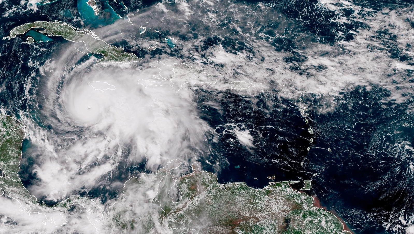
The island nations of the Caribbean, however, were not so lucky. Hurricane Melissa killed at least 45 people in Jamaica, before marching across Cuba, Haiti, and the Dominican Republic. As it moved slowly across the Atlantic, it fed on warm waters made up to 900 times more likely by climate change, increasing its wind speeds by 10 mph (which might not sound like much, but increases the potential damages exponentially.) In addition, a hurricane is such a powerful force that it churns the sea, bringing colder waters to the surface, which would normally reduce the amount of fuel. But the region that Melissa was traveling across was also anonymously warm at greater depths, so what the storm dragged to the surface still supercharged it.
All this fuel helped the storm rapidly intensify, defined as an increase in maximum sustained wind speeds of at least 35 mph in a day. In fact, Melissa underwent a phenomenon called extreme rapid intensification, doubling from 70 to 140 mph in just 18 hours. Topping out at 185 mph, it’s tied for the second most powerful Atlantic hurricane on record, and tied for first place for the strongest when making landfall.
This is where the 2025 hurricane season gets exceptional. While only five Atlantic hurricanes formed — half the number predicted — four of those, including Melissa, reached major strength. (The average number of named hurricanes in a season is seven.) That means 80 percent of the storms managed that feat this year, compared to the average of 40 percent. So while this was the first year since 2015 that a hurricane didn’t make landfall in the U.S., it’s only the second year in recorded history to have produced three or more Category 5 storms.
This is the worrying signal of climate change: The hotter the oceans get, the more fuel to supercharge storms. Yes, in some years that atmospheric force field might help the U.S. dodge landfall, but the hurricanes that do make it ashore will only get more powerful and more destructive from here.
Correction: This story originally stated that four hurricanes reached Category 5 this season, when in fact four reached major strength, including Gabrielle, a Category 4.
Source link
Matt Simon grist.org