2. The Territory
The area under study is the castral or
iqlīm territory of the town of Chinchilla during the Andalusi period. Its precise boundaries are not exactly known, but it would approximately correspond to the eastern third of the current province of Albacete (
Figure 1 and
Figure 2). The eastern sector is an area bordered on its eastern flank by the southeastern foothills of the Iberian System and the northeastern reaches of the Prebetic Range, between which lies the Almansa Corridor. This traditional pathway followed the route of the Via
Heraclea or Via
Augusta, a transit space between the Levante and southeastern peninsula and the Meseta and Upper Andalusia. To the north, it is bounded by the canyon of the Júcar River and the valley of the Cabriel River, between Alarcón and Iniesta (Cuenca) and the Muela de Cofrentes (Valencia); to the south, it borders the Campo de Hellín, where the Mundo and Segura rivers converge, and to the east, the plains leading to the Campo de Montiel through the Ruidera Lagoons.
The territory has an average altitude above 750 m, with areas exceeding 1000 m, which gives it a Mediterranean climate with some continental features, mainly manifesting in low winter temperatures. The absence of major rivers and their endorheic terrain means that much of the rainfall ends up in a series of lagoons—mostly saline and, to a lesser extent, freshwater, depending on the geological substrate—which has influenced population patterns throughout historical periods. Settlements have typically been established near these lagoons, as well as around the few springs and water sources.
The geographical characteristics of the region have dictated that, since the earliest documented times, its main resource has been the raising of sheep and goats, supported by extensive grazing areas that did not conflict with the dry farming lands. According to Felipe II
Relaciones Topográficas (written in 1579): “Sheep and goat herds are raised in this land; there is a great need for mules here because there is so much farmland, but they are not bred in this land […] Excellent oxen are bred for plowing, although they are few…” (
Carrilero et al., 2014, p. 88). During specific periods of the year, Chinchilla’s territory hosted numerous herds: “The land of this city is where many herds from the Serrania of Cuenca, Molyna, and Guete lands, especially from Guete, come to graze. The pastures here are not delicate; it is not a land of abundant grass. The herds survive the winter on branches such as rosemary, thyme, sage, broom, kermes oak, and others similar to these. Hunting preserves: all estates of this city used to have a hunting preserve for rabbits and a communal grazing area for the oxen that worked those lands” (
Carrilero et al., 2014, p. 86).
These herds not only allowed for the exploitation of the territory with minimal human resources and investment—limited to corrals, wells, and watering holes—but also would provide wool and leather, which were highly valuable in urban markets, as well as horns, antlers, and, to a lesser extent, milk and its derivatives, especially cheese.
The farmsteads and hamlets that traditionally developed in the area until the mid-20th century relied primarily on sheep and goat farming as their main economic resource. This activity was supplemented by small plots primarily used for a wide variety of cereals, along with some vineyards, almond trees, and, very occasionally, a few olive trees—all rainfed and produced mainly for self-sufficiency. Hardly any areas are artificially irrigated in the region due to the geographic conditions described, particularly the absence of fertile river valleys and the harsh winters, which hinder the cultivation of subtropical irrigated crops.
2.1. Routes and Drovers’ Roads
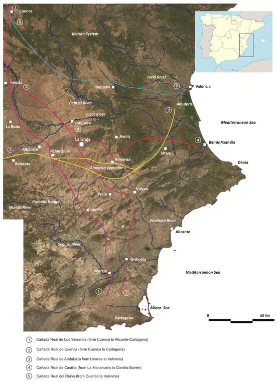
One of the defining characteristics of the historical land occupation model is the arrangement of communication routes, both in terms of the placement of population centers and the structures meant to protect them, such as castles and towers, as well as those that support trade and the movement of people, whether they be military or civilian, such as granaries, pens, cisterns, and inns. The geographical position of the territory we are discussing on the Iberian Peninsula gives it significant strategic value, as it is traversed by important natural communication routes, both in the north–south and east–west directions, which connect the Southern Plateau with the Levante and the mountainous Iberian System with Upper Andalusia and Murcia (
Jiménez-Castillo et al., 2021, pp. 36–45).
The first of the routes was, in Roman times, the Via Augusta or Via Herculea, which connected Cástulo in the Upper Guadalquivir with Sagunto on the Mediterranean coast, with a branch that continued through the Vinalopó to the final sector of the Segura River valley. On the western section of the so-called “Hannibal’s Route”, which led towards Baetica through Cástulo, there were mansions such as Saltigi (Chinchilla), Libisosa (Lezuza), and Mentesa.
The second connected the cities of Complutum (Alcalá de Henares) and Toledo, in the center of the peninsula, with Carthago Nova (Cartagena) in the southeast. Its itinerary is also known in the Middle Ages thanks to the Arab geographer al-’Uḏrī. It was mentioned in Islamic sources on the occasion of the passage of Umayyad troops in 925, when ’Abd al-Raḥmān III undertook a military campaign that would lead him to Pamplona. Ten years later, the same caliph undertook a military campaign against the rebels of Saragossa, in the course of which he traveled from the southwest northwards across the lands of what is now the province of Albacete through the lagoon areas of the River Jardín, Balazote, Chinchilla, and Puente Torres, where he crossed the River Júcar in the direction of the cora of Santaver. This is the same route used by the Almohad caliph Abū Yacqūb Yūsuf in 1172 against Huete (Uabḏa), passing through the lagoon area of the River Jardín (al-Gudur), Balazote (Balāṭ aṣ-Ṣūf), the marshland of Albacete (marğ al-Basīṭ), and, from there, following the right bank of the river Júcar (uādī Ğazīrat Šuqar) in the direction of La Almarcha and from there to Huete.
The region is also traversed by drovers’ roads or livestock routes, which were established following the creation of the Mesta by Alfonso X in 1273, shortly after the major expansion of the Christian kingdoms that reduced al-Andalus to the Kingdom of Granada. One of the main routes is the Cañada Real Conquense, which connected the lands of the Iberian System with the southeastern part of the peninsula, divided into two branches. The westernmost branch passed through Chinchilla, Jumilla, and then continued towards Murcia and the Campo de Cartagena. The eastern branch, known as the Vereda de Los Serranos, crossed the Júcar River near Jorquera and passed through the area under study, including Higueruela, Bonete, Corral-Rubio, Montealegre del Castillo, and from there to Yecla, located in the Murcian Altiplano. The Vereda de Los Serranos was used until the mid-20th century. However, its disuse has led to its occupation and, in some cases, its disappearance due to encroachment by local farmers. Today, only the sections that coincide with significant paths remain intact.
From west to east ran the Vereda Real from Andalusia to Valencia, which, crossing the southern part of the Chinchilla region, reached Bonete, passed through Montealegre del Castillo towards Caudete, and then continued in the direction of Fuente la Higuera, from where it headed to Játiva and the coastal plains of Valencia.
On both sides of the cattle routes, pens were built over time, both for local and transhumant livestock, with rest areas and counting stations serving as traces of the passage of migratory herds, which set up temporary and portable enclosures. Thanks to the cartographic work carried out between 1889 and 1893 by the National Geographic Institute, we know that around 1900, there were 42 pens in the Higueruela area. Of these, 21 are located along the Cañada de Pajares, from the northern boundaries of the area, which were established at the beginning of the 14th century, as indicated in the boundary document between Chinchilla and Jorquera, up to the summit of Molatón and the Sierra de Higueruela. South of the pass, another 19 are documented, all of them located close to the cattle route and around the village of Higueruela, especially on the sunny slope of Oncebreros, sheltered from the prevailing northwest winds.
Now, these traditional cattle routes and trails, which have undoubtedly been used since the establishment of the Mesta, raise a key question: did they develop from this moment onward, or could they date back to the Andalusi era?
Julius Klein (
1920), a pioneering historian of the Mesta, believed that the Iberian system of trails and cattle routes dated back to protohistory and had been in continuous use until the 13th century. However, Ch. J. Bischko promptly corrected him: “Undoubtedly, both in the caliphate period of al-Andalus and later (especially under the Almoravid and Almohad dynasties), there were seasonal movements of livestock between the pastures of the countryside and the mountain ranges beyond the provincial boundaries of the
kūras,
5 as this was familiar to the Hispano-Berber shepherds based on Maghreb practices; but with the possible exception of the Cañada de Cuenca or the drovers’ trails, there is nothing to suggest that the Mesta adopted a system of Muslim origin. Certainly, Klein’s view, according to which the conditions of the Reconquista did not hinder the regular and peaceful movement of livestock across the frontier through the Meseta, is in itself improbable and contradicts what the chronicles tell us about the endemic raids and livestock thefts that prevailed in all the frontier districts”.
6Probably, this type of livestock farming is represented in a ruling by the
qadi ‘Iyād concerning a group of shepherds who lived in a small settlement (
qarya) along with their families and others who were likely arable farmers. The issue at hand was that these shepherds sought to be exempt from paying the salary of the
imam of the mosque under the same conditions as the other registered inhabitants, claiming that they did not remain in the village for more than a few days as most of their time was spent elsewhere with their livestock (
Ibn ‘Iyāḍ, 1998, p. 74). The exact duration of time these shepherds were away from their settlement is not specified, but since the
imam led the prayer every Friday, the complaint would not make sense if they only left for a few days. It could only be justified if their absences lasted at least several weeks or possibly even months. Therefore, the
fatwa issued by the
qadi ‘Iyād must be understood as evidence of the existence of some form of transhumance or seasonal livestock movement.
2.2. Caves and Shelters
The pens and sheepfolds, both those constructed and those that utilize a natural shelter or rocky overhang to create a corral or enclosure, are spread throughout the La Mancha region. These are typically associated with the resident livestock of nearby towns and villages. Their types vary depending on the significance of livestock farming in each area, which is, in turn, related to the arable and livestock possibilities of their surroundings.
Among the shelters used for livestock purposes, those that have been in use from Antiquity to the Andalusi period are particularly abundant. This prolonged occupation over time is confirmed by the discovery of ceramic fragments, which are typically found alongside those from the modern and contemporary periods, given the long-standing occupation of these caves. Their use may have been seasonal, though in some cases, it could have been permanent, as evidenced by the structures built outside the caves to expand the residential space, improving the living conditions of the inhabitants and relegating the shelter to a pure livestock function, such as a corral.
An interesting case that has been the subject of archaeological interventions is the Cueva del Lagrimal in Villena, occupied during the first half of the 13th century (
Soler & Pérez, 1991). In the area under discussion, another good example of this type of settlement is the Cueva Negra del Mugrón, located between Almansa and Ayora (
Figure 3). Outside this cave, a building was constructed with a single nave divided into three rooms to serve as shelter and residence for its inhabitants. Additionally, an adjacent courtyard or pen featured small rooms for storing tools or meeting the specific needs of livestock, such as birthing pens. Due to its size and location, it seems reasonable to assume that these shelters were related to nearby villages in the plain, though they may have had a certain functional autonomy. These shelters are particularly abundant on the southern faces of the Chinchilla, Higueruela, and Carcelén mountain ranges. Occasionally, they are documented on the northern slopes at considerable altitudes, a factor that should be linked to the use of summer pastures and transhumant livestock activities (
Simón García & Hernández Carrión, 2013).
One of the densest rock shelter complexes is located on the slopes of the Mugrón mountain range, where a considerable number of caves and shelters, with varying depths, were used as refuges for local livestock. This has been attested to from Prehistory until the middle of the last century. These shelters can be classified into three types:
- (a)
Caves or shelters without any construction, but where the presence of shepherds with their livestock has been confirmed through ceramic remains from Antiquity up to a century ago;
- (b)
Shelters with enclosures and, in some cases, a small refuge or separate space for the shepherds, such as the shelters at Azegadero de las Zorras, which is the most common type;
- (c)
Caves and shelters with domestic buildings on the exterior. The best representative of the third group would be the Cueva Negra (Almansa), located at the foot of the eastern slope of Mugrón on the Los Nogales or Blanco de Abajo estate. In this shelter, constructions similar to those of the villages are observed, consisting of two or three rectangular rooms around a courtyard–corral and a wall, which serves as a fence, enclosing the corral inside the shelter. A similar site is found on the opposite slope, where the Abrigo del Rincón de San Pascual and the Arch de San Pascual are located. These include medieval and modern graffiti in the larger shelter of the northeastern valley (
Meseguer, 1990, p. 379), where some exterior structures are also visible, smaller in scale than those in Cueva Negra but similarly used for livestock purposes.
Another group of shelters with medieval occupation appears throughout the mountain range slopes, especially on the southern slope, notably in the Cueva del Puntal and the Abrigos I and II, all of them in the Mugrón Range (Almansa) (
Jiménez-Castillo & Simón García, 2017, p. 221). In all of these, as in the previous ones, fragments of cooking pots provide a more secure identification of Islamic occupation. Additionally, fragments of glazed ceramic dishes in green or amber and greenish-blue glazed flasks suggest that they were inhabited until the Christian conquest of the area in the mid-13th century. After that, their use seems to have decreased and become more sporadic, at least judging from the analysis of the surface ceramic record. All of these small settlements and shelters are connected to the medieval village at Castellar de Meca, primarily of Islamic origin, the most significant Andalusi settlement in the examined territory and the only one where the presence of a pottery workshop producing common ceramics for regional distribution has been detected to date (
Simón García et al., 2024).
2.3. Water Supply
In addition to pastures, livestock farming requires a sufficient water supply to allow the herds to drink daily, ensuring that water does not run out at any point during the season. Various systems were employed to supply water for livestock. Endorheic ponds or lagoons in the mountains, as well as groves, water tanks (balsas), and washing ponds (lavajos for rainwater) or seasonal pools and ponds (linked to a seasonal watercourse), were the most common methods in plains and flatlands. However, the most effective method was the aljibe (ar. al-ŷubb), an underground reservoir with a rectangular plan and a vaulted ceiling strategically located in areas that the livestock required during their movements. These reservoirs allowed the storage of potable water sourced from temporary streams or runoff and featured a settling tank at the entrance and one or more openings in the vault to extract the water.
The existence of these reservoirs is precisely one of the most reliable pieces of evidence we have regarding pastoralism in the study area during the Andalusi period. Strictly speaking, we do not have evidence of them before the conquest, but they are attested so close to it (and prior to the organization of the Mesta in 1273) that it seems highly likely their construction dates back to the Islamic period. For example, in the 1264 text in which the Castilian King Alfonso X granted the town of Almansa the
Fuero (charter)
of Cuenca, it states: “We also grant them the inheritance called the Hondón del Almugrón, as well as the one with the cistern (
aljibe) at the Ayora road against Almansa” (
Jiménez-Castillo & Simón García, 2020, p. 112). A similar cistern was later referenced for the partition of lands between Almansa and Montealegre del Castillo by Don Juan Manuel in 1338.
According to Lorenzo Cara, there were three types of medieval rural cisterns in Almería:
The Alpujarra mountain cistern: These measure between 6 and 9 m long by 2 to 3.5 m wide and have a door at the lateral end. They correspond to local and regional livestock farming and date from the late 12th century to the first half of the 13th century, according to archaeological evidence.
The Campo de Dalías type: These feature a slightly pointed vault and a lateral entrance, often with an intermediate transverse arch. They are associated with transhumant livestock movements to distant and extensive pastures. They date from the first half of the 14th century.
The large cisterns: Measuring between 20 to 30 m in length and 5 to 7 m in width, these cisterns can hold up to 800 cubic meters of water. Their naves are divided by four or five transverse arches, each with an opening in the vault. Dating from the second half of the 12th century
7, they are located along major droving routes and in large grazing areas, serving as resting stops or watering stations. However, Lorenzo Cara hypothesizes that these large cisterns were not only used for long-distance transit but also served as watering points for vast areas of around 1500 hectares, where stationary or seasonal herds grazed (
Cara & Rodríguez, 1989, p. 641).
The area where the
alquería (village) of La Graja is located, which we will examine in more detail, along with other nearby sites such as Malefatón, Casa de la Zorra, Villalta, La Erica de Piedra, and even the Castillicos de Mingo García, had the necessary water resources for livestock use. The area’s aquifers naturally and directly recharge, providing a significant amount of water without the need for artificial systems or constructed infrastructure. The springs tend to fossilize and persist, and farmers have traditionally avoided clearing or plowing near them to prevent damage. The traditional use of these wells and springs is supported by numerous hydronymic microtoponyms in the area, as well as those that are still in use or were until recently
8. Within the Cuerda de la Doblona, we find the hill of the Charcas, the area of Noria Pía, and the Pocico de la Hoz. Further north, there is the Pozo de Pedro Martín (3.3 km away) and the Pocico. To the east, at 3.2 km, is the Pozo de Elena; to the northwest, at 1 km, we find the Pozo Moro, located in one of the valleys formed by the irregular topography behind the site. Other wells are located farther away, such as Collado Hondo (6 km), the spring at the Colmenar hill (7.2 km), the Pozo de la Cardosa (5.7 km) to the north, the Fuente Jornada (5 km), and to the northwest, the Pozo de la Milagrosa (4.2 km). To the south, at the foot of Molatón, is the Carrasquilla watering trough (2.5 km away), which continues to serve the area’s herders, along with the toponym Lagrimales. A bit further south, near Mingo García, is Fuente-Lino (4.3 km); southeast is the Pozo de Casa Oroví (4.3 km), the spring area at Casas de la Peña (8.8 km), and the pit at the foot of the Colorados (6.8 km). Additionally, there is the significant Salobrejo lagoon, which is saline in nature and plays a vital role in animal feeding along the main route of the corridor.
5. Livestock Features of the Houses
The most common domestic model consists of large courtyards and few but extremely functional rooms, lacking certain specialized spaces like latrines (
Figure 8). The preferred side for constructing the building is the north so that the doors of the rooms opening to the courtyard face south, while the back of the rooms faces north or northwest to shield from the prevailing winds. The house could have several rooms with their own fireplaces, as in buildings 15–16 in La Graja, suggesting that it was inhabited by several conjugal units, with one unit occupying the main hall, where the presence of a sleeping area is particularly notable. In most homes, the courtyard does not occupy a central position, as the most common layout consists of only one or two wings in an “L” shape or facing on both sides of the courtyard. Examples with three or four wings are exceptional.
As far as we know, these domestic layouts are the result of the gradual addition of wings until a courtyard–corral was formed. In fact, alongside houses with courtyards, there are others with just a single wing, which could be considered potential courtyard houses. These are typically located in the peripheral areas, while they are absent from the central part of the settlement. This distribution has been documented not only in La Graja but also in other sites like Los Castillicos, Hoya Honda, and Los Villares del Bachiller. The area in front of these early houses, to the south, was rightfully theirs and was for the private use of the new dwelling. This is evident from the examination of the plans, which show these areas are always cleared. It is possible that this space was physically delineated with some sort of provisional structure—such as a wooden or branch fence—as has been documented in other
alquerías, such as the one in Uxó (Castellón), where it was found that this open space was about twice the size of the built area (
Bazzana, 1998, p. 50 and
Figure 3). This is important because, as we will see, the courtyards of the more advanced houses functioned as livestock pens, and it is also possible that these delineated spaces in the early homes, enclosed by provisional fences, could have served the same purpose.
The analysis of the construction evolution of the houses in La Graja has revealed that some walls, likely the oldest, show a construction style reminiscent of opus africanum. This technique involves the use of orthostats of variable sizes forming the external faces while the interior of the structure is filled with rubble. This is precisely the construction method used for the prayer hall of the mosque, one of the first buildings to be erected in the alquería, as suggested by the urban layout analysis. The other construction technique documented, likely corresponding to the relatively more recent walls, consists of common masonry with medium-sized, squared stones that leave very little space between them. These structures tend to be narrower than the earlier ones and appear to have performed better, as they generally show fewer deformations and construction issues.
Indeed, a chronological difference in the use of these two construction techniques seems to be evident across the site. The opus africanum appears to be more common in the earlier phases of the site (such as the mosque and phase I of house 14), while the masonry in herringbone or opus incertum style is more widespread in the later phases (such as the courtyard and service room of the mosque, phase II of house 14, and houses 15–16). This observation regarding the chronological differences will need to be confirmed in future excavations, but what is particularly significant now is that the more distinctive and seemingly older construction style, opus africanum, was precisely the one used to build the livestock pens associated with the alquería, including both the large pens of the houses and the enclosures on the outskirts of the settlement. As we will see next, this provides strong evidence for dating these structures to the 11th century.
5.1. The Proportion of Courtyards
The large size of the courtyards in the houses of these rural settlements stands out in relation to the total surface area of the plots. Specifically, the courtyards of the houses at La Graja, which we know with more precision, account for an average of 58.8% of the total surface area (
Table 1). This is a very high figure, but considering that we have only taken into account the excavated areas, i.e., houses 15–16 (78%) and house 14 (48%), and that the latter is the only one that seems to have had four bays in the entire abandoned settlement, it can be deduced that the actual percentage for the entire domestic complex would be even higher. This proportion far exceeds that of contemporary housing in urban outskirts; for example, the analysis of 33 houses from the outskirts of Córdoba, which were likely abandoned around 1031 and built approximately in the second half of the 10th century, gives a result of 35%. In later urban homes, such as those of Siyāsa, abandoned in the mid-13th century, the proportion of courtyards is 16% of the living space, based on a total of 14 examples. Therefore, we can state that there is a significant difference in the size of courtyards between rural and urban domestic spaces in general. The causes of this disparity must be related to two factors: (a) the saturation processes experienced by urban fabric, especially in the later examples, and (b) the different tasks and uses carried out in the courtyards of both types of households. In this sense, while the courtyards of houses in towns primarily served as sources of light and ventilation and for carrying out daily domestic tasks, the courtyards in the rural houses also functioned as productive spaces for some of the agricultural and livestock activities that supported the economy of their inhabitants.
So far, these differences between rural and urban domestic buildings in al-Andalus have not been quantified by comparing absolute figures regarding the relationship between courtyard size and plot area. However, the divergence had already caught the attention of some researchers simply through observing available floor plans
10. What has not yet been analyzed is the inequality that can also be observed among rural house courtyards depending on the predominant productive activity (Table). Indeed, the proportion of courtyards in the houses of La Graja (58%) is significantly larger than that in the dwellings of the village of Foietes (also from the 11th century) in Finestrat (Alicante), which is 24%, and the nearby settlement of Tossal de l’Almisserà at 29% (
García et al., 2004, p. 90). The courtyards in Alcaria Longa, in Mértola (Portugal) (
Boone, 1992, p. 53), cover approximately 30% of the total area of the dwelling, similar to the nearby
alquería of Odeleite (30%)
11. However, the houses in La Mancha that we have been studying resemble, in this sense, those in the
alquería of Jolopos in the mountains of Granada, where courtyards occupy an average of 56% of the domestic area, as well as those in the alquería Cújar (50%) at the foot of the Sierra de Alfaguara (Granada) (
Rodríguez Aguilera, 2024). La Graja and Jolopos are distant settlements located in different regions, yet they share the characteristic of being situated in dryland areas, unlike the villages of Foietes, Almisserà, and Alcaria Longa, which were predominantly irrigated.
In the territory of Jolopos, “irrigated agriculture was clearly not the basis of the economy”, which was “mainly based on silvopastoralism” (
Bertrand & Sánchez, 2002, p. 155), similar to the villages of eastern La Mancha. However, the Portuguese and Alicante settlements based their economy predominantly on the intensive cultivation of fertile irrigated lands. There is also no evidence of irrigation at El Quemao (Teruel), an
alquería located in a geographic area very similar to that of the southeastern La Mancha settlements. In this case, however, the courtyard size proportion is only 28%. Similarly, in another dryland alquería like Las Sillas, in the Monegros Desert, a similar situation is observed based on the few housing samples we have examined for this purpose
12, where the proportion would be around 20%. In these cases, the difference in the figures from El Quemao and Las Sillas compared to the percentages for La Graja and Jolopos cannot be attributed to the distinction between irrigated and dryland agriculture. Instead, we believe this can only be explained by the fact that in the latter two, the large courtyards were likely also used as livestock pens. This livestock-oriented purpose would have led to layouts similar to those of traditional corrals and farmsteads in this region or those studied by Lorenzo Cara in Almería, with an essentially pastoral function. It is necessary to emphasize that none of these productive strategies we refer to were purely agricultural or livestock-based
13; rather, the differences between them are related to a certain degree of specialization within the economic choice.
5.2. Entrances
Apart from their dimensions, the entrance doors from the outside also display particular characteristics in their arrangement: while in livestock-oriented villages, they provide direct access from the courtyard to the outside, in agricultural ones, access to the courtyard is through an entry hall. Typically, in these extended entry halls, the two doors (to the street and to the courtyard) are staggered to create angled passageways, preventing the interior of the house from being seen from the street. These transitional spaces between the exterior and the courtyard usually open onto stables, as can be seen in Odeleite, Alcaria Longa, and Foietes, for example. Naturally, the presence of such entry halls makes it more difficult for livestock to access the patio–courtyard, which explains why they are present in agricultural alquerías and absent in livestock-oriented ones. This feature also represents a specialization of the built domestic space that is characteristic of urban contexts, and its gradual appearance in certain rural settlements can be considered an indication of increasing urbanization.
In the houses of La Graja, it is evident that the openings connecting the patios to the street are excessively wide for the passage of people alone or even pack animals (
Figure 8). The three entrance openings from the exterior of houses 15–16 measure 1.5, 1.6, and 2.0 m in width, while that of house 14 reaches 2.6 m—considerable widths that contrast with the access openings to the rooms, which range between 55 cm and 1 m. For example, in the abandoned settlement of Siyāsa, located 80 km south of La Graja (
Figure 1), the openings providing access from the street to houses with stables, through which people and pack animals had to pass, were notably narrower: the door connecting the entry hall of houses 10, 12, and 14 with the alley measured only 1 m, the same width as the door providing direct access to the stable of house 6 from the outside. From this, it can be deduced that the doors connecting the patios of the houses of La Graja with the street were intended for the passage of small herds of sheep and goats, thereby confirming the hypothesis suggested by the size of the patios.
The southeast quadrant of courtyard 15 was sectioned off by a wall composed of two walls forming a right angle, creating an almost square space of 72 m
2. This segregated part of the courtyard was accessed through two doors: the first connected it to the rest of the courtyard at the northeast corner through an opening 1 m wide; the second led to the exterior on the south side through a door 1.53 m wide. There were no partition walls in this space, although we found a rustic stone pillar base, likely used to support a post, which would have served as a support for an overhang covering the rectangular area on the eastern side of this space. This type of shelter is common in traditional rural architecture and is often intended to serve as a stable or shelter for domestic animals (
Sánchez del Barrio, 2009, fig. 2). Similar features have also been documented in
Andalusí sites close in time to La Graja, such as Albalat (Cáceres), where support structures were also formed by vertical wooden posts (
Gilotte, 2020, p. 224). This arrangement of the segregated corral allowed animals to enter and exit without crossing through the rest of the domestic area, while the inhabitants of the house could access them directly from the patio.
In summary, from the analysis of the data presented, it can be concluded that the courtyards of the villages in La Mancha that we have been analyzing served typical rural functions and additionally played an essential role as corrals. This livestock-related use also explains the width of the entrance opening to the courtyard from the street, which would be excessive if it only served to facilitate the passage of people and pack animals. In fact, traditional farmsteads (corrales) built in the area up until the early 20th century, as well as others whose remains are still visible and were already abandoned when the region was mapped in 1898, have patios similar in organization and proportion to those we are examining, as well as large entrance doors with the same characteristics, specifically because they were used as animal shelters.
5.3. Livestock Pens Behind the Houses
Of the 42 domestic structures identified, 13 included a rear pen. These spaces, typically adjacent to the northern side of the house (
Figure 6), vary in size and layout, generally taking on quadrangular or polygonal shapes. Notably spacious, they often exceed the size of the domestic core itself, sometimes by a significant margin. Their dimensions range from 215 m
2, as seen in the one associated with house 11, to an impressive 3500 m
2 in the case linked to house 14 (
Figure 6, no. 14). It is possible that some of the larger sheepfolds (e.g.,
Figure 6, no. 13 and 45) were shared by multiple families, though we lack definitive evidence to confirm this.
The preserved base courses of the walls that enclosed these pens are made with a masonry technique similar to the rustic opus africanum of the houses, consisting of rubble and orthostats. The sides of the pens show accumulations of stones from collapsed structures, but they are much less voluminous than those associated with the houses, from which we can infer that their elevation was likely much lower.
Since no internal structures have been preserved, it is possible that the upper part of these fences was not made of masonry but of plant material, such as thorn bushes, an option that has ethnographic parallels
14. Thanks to these parallels, we know that thorn bushes offer multiple advantages, such as clearing thorny bushes from grazing areas, preventing goats from escaping since they cannot climb or scale walls finished with such material, and also deterring wolf attacks, as wolves are capable of overcoming walls of considerable height. Additionally, the rocky surface outcrop prevents any form of cultivation, suggesting these were large pens intended primarily for housing livestock. They likely served complementary functions to the patio–courtyard, such as sheltering livestock not in breeding phases, though in reality, we have no material evidence to clarify their specific uses beyond the ethnographic information from the area, which suggests that traditionally, enclosed areas annexed to homes like these were used to store livestock and for related purposes
15.
One of the most interesting aspects from a historical point of view is that these livestock pens were not part of the original design of the house but were built at a later stage. As we mentioned earlier, the houses developed from an initial bay; first, the patio–courtyard was defined by constructing the rooms around it, and later, the rear livestock pens were added. House 14, for example, was initially limited to the side bays with the patio–courtyard in the center; later, the large pen located behind houses 14 and 17 was delimited by constructing the stone fence that closed the space between the two domestic structures. There was no direct communication, or at least we have not identified one, between the domestic area of house 14 and the pen (
Figure 6, no. 13); access to the pen seems to have been from the street to the east of house 14, although this has not been securely identified yet.
This process seems to have followed a similar pattern in the other cases; first, the house (with its patio–courtyard) was established, and at a later stage, the livestock pen was added by appropriating and enclosing an area that had previously been vacant. These pens are, thus, expansions of the original plot, extending to the north of the domestic areas (houses 5, 6, 7, 14, 17, and 22), to the east (houses 22 and 39), and to the west (houses 5 and 8). The houses located in the center of the settlement had to opt for smaller pens (houses 10, 11, and 20) or even forgo them altogether, as in the case of houses 15–16, which could not have a rear pen because behind it was the mosque plaza. It is possible that the owners of this house, who could not incorporate a large adjacent space for a pen, made use of one of the large enclosures whose remains are found on the outskirts of the alquería, though this is a conjecture that we cannot confirm at this time.
This widespread expansion of plots, which essentially involves the growth of areas dedicated to productive uses, and in this case livestock farming, through the appropriation of free space for pens, follows a logic that we believe is related to the economic development of these peasants. It seems reasonable to think that, originally, the patio–courtyards were sufficient for the residents’ needs, but they likely became inadequate due to the growth of herds, indicating the development of extensive livestock farming and possibly the associated commercial activity. It should be noted that not all the alquerías we know show such an advanced process of pen creation as in La Graja. In Hoya Honda and Dolonche, for example, only one such space is clearly identified, and in La Toyosa and El Bachiller, perhaps two, while in Los Castillicos, none are visible. We will return to this issue later and explore the reasons that could explain these differences.
6. Zooarchaeological Findings: The Multi-Proxy Perspective
Excavations at La Graja have provided limited information from a zooarchaeological perspective, yet it is essential for understanding the relationship between domestic–productive architecture and livestock management. To maximize the information obtained from the archaeological record, a series of analyses has been employed to study this fleeting organic imprint.
The most significant record corresponds to the archaeofaunal material found in scattered locations, especially in the courtyards
16. Preliminary identification indicates a livestock specialization in sheep/goats, as they represent nearly the entire identifiable taxonomic profile (96%). Indeed, the most interesting discovery undoubtedly occurred in one corner of courtyard 16, where, during the 2022 excavation season, we unearthed a sheep skeleton (
Ovis aries) that, based on carbon-14 analysis, can be dated at its highest calibration to between 948–1030 CE
17 (
Figure 9). This skeleton belongs to an adult female, approximately 6–8 years old, who, judging by her bone structure, had undergone numerous births. The skeleton was fairly complete, with the exception of the limbs, and in anatomical connection, indicating that the bones had not been scattered, as is usual when a carcass is left in an area where scavengers are present, but rather, it appears to have been semi-buried. These remains, along with other fragments, including two jaws, demonstrate that sheep farming and, to a lesser extent, goat farming must have been the primary livestock activity, as it has been historically in this region, given the previously mentioned geographic conditions. Based on these preliminary findings, it can be inferred that sheep management would have been one of the most important activities for the economy of peasant families in La Graja, possibly intended primarily for the production of wool and milk, as suggested by the average age of slaughtering, with some senile specimens reaching 8–10 years (
Moreno-García & Pimenta, 2011).
Additionally, a tooth(P3) and a humerus from a bovid (Bos taurus) were found. Although there is no complete record, this suggests the presence of these animals among the livestock of the village’s human group, either as draft animals for their meat and other products or, more likely, for all these purposes.
Al-Rāzī (10th century) highlights the production of milk and its derivatives in the marshes of the lower Guadalquivir, a district abundant in cattle, which were also used as draft animals (
Lévi-Provençal, 1953, pp. 93, 94). This was similarly the case in certain areas of the peninsula with higher rainfall, such as those around Lisbon, Alcácer do Sal, Coimbra, Guadarrama, and the Serranía de Ronda (
Lagardère, 1993, pp. 443, 445). At least during the Nasrid period, for which we have more data, draft oxen were concentrated along the coast, where the flat terrain favored plowing, while they were scarce in mountainous areas (
Lagardère, 1993, p. 446). However, as we have seen, by the 16th century, oxen were also raised for plowing in Chinchilla.
Bone remains of chicken (Gallus domesticus) were also identified, further completing the information on the diet and production activities of the families.
Once again, Arabic sources support the relative importance of raising these animals. Specifically, al-‘Uḏrī highlights the exploitation of cattle in Tudmīr, the province of al-Andalus in which the studied territory is located, and various breeds of horses, with an annual export of 1000 head (
Molina López, 1972, pp. 47, 48). The discovery of several horseshoes in different dwellings of La Graja confirms the certain and relatively abundant presence of equids, likely used for transportation and agricultural work.
In summary, documentary and archaeological sources suggest a livestock specialization in goats and especially sheep. There are also indications of diversification in fauna for consumption, such as chicken farming and small game hunting (hares). Large mammals like bovids and equids appear as well, which, given the analysis of sheep herd management, were likely more related to agricultural use than meat consumption, only being discarded when they could no longer work.
Alongside direct data from the faunal analysis, other findings include palynological studies, which preliminarily show the presence of spherulites from ruminants, likely sheep/goats, in almost all analyzed areas, including courtyards, multifunctional rooms, and kitchens
18. This could suggest direct cohabitation between people and animals in these enclosed spaces during a later, residual phase when the dwellings were used for pastoral purposes. Biomarker analysis has further reinforced these findings, showing an accumulation of pasture and shrub remains in the courtyards, possibly related to animal consumption and evidence of systematic burning inferred from altered samples—a common practice for purging and sterilizing animal spaces
19.
7. The Sheepfolds
To the north and west of the hamlet of La Graja, beyond the rear pens of the houses, several long walls can be observed. These appear to correspond to spacious enclosures that extend around the periphery of the settlement (
Figure 6). They are built using the characteristic construction technique found in the pens, the oldest phases of the dwellings, and even in the mosque. This technique consists of two faces made of large orthostats placed vertically, with the interior filled with rubble (
Figure 10,
Figure 11 and
Figure 12).
The walls are somewhat thicker than those of the buildings within the hamlet, measuring an average thickness of 0.9–1 m and a preserved height of 0.2–0.5 m, while the walls of the houses measure between 50 and 60 cm in thickness. It does not seem that all the walls were built at the same time, as their thicknesses are not uniform, and there is no apparent macrospatial planning organizing them. However, it is evident that they are medieval and contemporary to the settlement, given their peculiar construction technique, which is similar to that of 11th-century buildings and entirely unrelated to the region’s traditional or popular architecture (
Figure 13)
20.
The northernmost wall stands out due to its length—190 m (
Figure 5,
Figure 6 and
Figure 14). At first glance, it might appear to be a boundary wall separating the cultivated area, a small hollow, from the settlement. However, both in a 1957 photograph and today, it is separated by about 5 m from the settlement. Its presence has encouraged the growth of holm oaks and kermes oaks, which almost completely conceal it, but its course is still discernible. It has no connections to other structures, nor are there any walls abutting it. Only at its eastern end is there a similar structure running north to south, interrupted by a terrace to the north and extending to the current path to the south. Near its western end, other walls with the same characteristics can be seen.
In the case of the southern wall (
Figure 6 and
Figure 14), the delimited rectangular area (the preserved sections form a large L-shaped structure) could be interpreted as the remains of a large enclosure, although no further precision can be made at this time. The described structures form, as can be seen on the general map, a transitional or passage area resembling an irregular street or alley. On either side, there appear to be wide spaces that were logically enclosed, although most of the walls that would have defined them are no longer preserved.
The only enclosure whose complete layout can be approximately reconstructed is located at the westernmost point of the complex (
Figure 14, no. 49). Irregular in shape, as it adapts to the topography, it is notably elongated, stretching in an east–west direction. It measures approximately 240 m in length, with a variable width averaging around 40 m, resulting in a substantial area of approximately 8800 square meters.
From the analysis of the general plan of the hamlet and the enclosures, several observations arise that allow for the formulation of hypotheses. First, the irregular layout of the enclosure walls, likely due to their adaptation to the terrain without any prior demarcation, contrasts sharply with the much more regular, even geometric layout of the pens behind the houses. It is true that a significant portion of the layout of pen number 13 is also irregular; however, in this case, it appears that a large part of the wall belongs to an earlier sheepfold, which was repurposed.
Second, the walls of the enclosures do not appear to be entirely contemporary with one another. Most importantly, they seem, in general, to predate the domestic pens and even some of the houses, such as numbers 3 and 4. These houses were likely within an enclosure delimited to the north by wall 1 (
Figure 6), with a southern wall that has since disappeared. This observation regarding the chronology of the enclosures aligns with the construction technique used, which corresponds to the earliest phase of the settlement, as previously mentioned. Although these are indications rather than definitive evidence, they are worth considering as they may support a significant hypothesis regarding the origin of the hamlet itself, as will be explained later.
To interpret these enclosures, we have to turn to ethnographic parallels, as numerous traditional structures of this type have been preserved (
Figure 13). Some of these can be traced back to the Middle Ages, though most are more recent, with some even remaining in use until the mid-20th century. These are large sheepfolds, known by various names depending on the region, such as “majadas”, “tinados”, “apriscos”, or “rediles”. We also refer to them as “sheepfolds”, a term we will use here to distinguish them from the courtyard–corrals and the rear pens of the dwellings.
Despite general spatial similarities, the sheepfolds at La Graja are distinguished by the unique construction technique of their walls, unlike others where simple coursed masonry is used. These structures provided protection for livestock, prevented issues with predatory animals, and allowed shepherds to keep the animals under control.
Sheepfolds of this type have been recorded in various areas of the provinces of Albacete, Cuenca, Ciudad Real, Castilla y León, Asturias, and elsewhere, often near the routes of the Mesta. According to Fernández Maroto and Picazo, these enclosures are generally related to the transhumance of sheep, which passed through these regions for centuries
21. They might also be connected to sedentary herds, although, for these authors, the large number of sheepfolds still visible in the Valdepeñas area, which they studied, suggests the presence of transhumant livestock that arrived at certain times of the year. If they were intended solely for local livestock, the enclosed space would be excessive.
In the province of Albacete, these
majadas (sheepfolds) are abundant, some of which were studied by one of us (JLSG) in collaboration with Emiliano Hernández. Along the trails and drovers’ roads that cross the lands of Albacete, we find dry-stone constructions related to the annual movements of sheep herds from neighboring or transhumant provinces, such as the
Contadero (counting point) of
Los Serranos at the intersection of the municipalities of Hoya Gonzalo and Higueruela, where the herds were counted after crossing the Júcar River; or the
Descansadero (resting place) of the
Vereda Real de Andalucía in Bonete, which preserves numerous dry-stone corrals with small
cucos or shepherds’ shelters (
Simón García & Hernández Carrión, 2013, p. 75).
What interests us most now is a series of locations with complexes of enclosures closely resembling that of La Graja. The first of these is in Masegoso and consists of several corrals arranged on either side of the drovers’ road, which serves as a central axis (
Simón García & Hernández Carrión, 2013, p. 77) (
Figure 13). The second complex is located between the village of Ituero and the
Vereda Real de Andalucía, where corrals of highly variable sizes are scattered over an area of approximately 15 hectares (
Simón García & Hernández Carrión, 2013, p. 81). The third is in Peñarrubia, on both sides of the
Rambla de la Cañada del Toril and 1 km from the
Cañada Real.
Other similar complexes in the province of Albacete are cited by these researchers in the village of El Berro, near the
Vereda de Peñascosa at its junction with the
Cañada Real de Andalucía; at the summit of Cerro de Santa Bárbara,
El Santo, and
El Cucharro in Alcaraz; at Cerro Vico in Bienservida; in the eastern sector of the Vianos municipality; and in Alborea (
Simón García & Hernández Carrión, 2013, p. 84).
The general characteristics of these complexes of enclosures are that they lack a specific layout or defined shape. They consist of irregularly shaped spaces, generally tending toward an oval form, constructed on flat or slightly sloping terrain. Smaller enclosures are attached to them, seemingly without any specific planning, except for the purpose of separating livestock for management reasons, such as birthing areas, shearing, or housing tame animals. Some corrals feature two walls extending outward from the gate in a funnel shape to facilitate gathering the livestock. The walls are built by collecting stones from the surrounding terrain—irregular limestone blocks of varying shapes and sizes—with no evidence of stone-cutting work. Both the interior and the surrounding areas of the corrals are cleared of stones, which are used for the walls or piled into linear or circular heaps. This arrangement allowed for the growth of herbaceous plants and pasture within the enclosures. We can relate these clusters of majadas with transhumant and semi-transhumant livestock practices, as stationary livestock farming alone does not require such extensive corral infrastructures.
The enclosure of livestock in these sheepfolds, in addition to serving all the purposes outlined—directly related to the management of livestock herds—also allowed the use of sheep manure to promote the growth of pasture in areas prone to shrub encroachment. This practice contributed to seeds contained in the excreta and enhanced the soil’s water retention capacity. In fact, on the 1865 Madoz map of the current province of Albacete, the area known as Cuerda de la Doblona appears as Cuerda de Las Grajas. In the first 1:50,000 edition of the IGN map, created in the late 19th century, the area where the site of La Graja is located is labeled El Verdinal, referring to the emergence of a natural grass cover that develops with ease even under a modest rainfall regime.
The grouping of pens and sheepfolds can be associated with transhumance, as they were used as resting places and counting points, as previously discussed. However, their use should also be linked to the “extremos”, meaning the areas where livestock spent some seasons, located at the starting or ending points of the migration routes. As mentioned, in the 16th century, the chroniclers who compiled the Relaciones Topográficas of Chinchilla noted that this area was an “extremo” for the mountain livestock herds coming from Cuenca and Huete to spend the winter here. Lorenzo Cara stated the following by the end of the Nasrid period (13–15th centuries):
- (1)
Pastureland in extremes was composed of lands dedicated to cereal crops, with fallow cultivation and alternating production, reserved for resident herds.
- (2)
Land exclusively dedicated to pasture, divided into specific areas allocated for each species.
- (3)
Fallow fields left uncultivated for a long time, reserved for riverside and resident herds.
- (4)
Unmown meadows or ungrazed stubble fields, set aside for cattle.
- (5)
Highly manured land, where the first autumn rains would produce abundant grass (constituting the
redondas where transhumant herders practiced
majadeo,
22 resulting in superior-quality grasses).
It is precisely this last category that we believe could be identified with the group of communal sheepfolds of
La Graja (
Cara, 1999, pp. 130–131).
Structures of this kind have been built and used for centuries, lasting until practically the mid-20th century. Indeed, in aerial photographs from 1957 (the “American Flight”), a fragmented landscape of enclosures formed by long, patiently constructed walls—sometimes spanning several kilometers—can still be observed in different areas. Lorenzo Cara explains that among the shepherds, it was the
merineros23 who most significantly altered the landscape, suggesting that at least a substantial portion of these structures in the Kingdom of Granada date from the 16th century onward (
Cara, 1999, pp. 130–131). Most of these structures date to the 18th and especially the 19th centuries, when land was divided into plots following the Disentailment (
Desamortización), leading to medium-sized herds typically owned by local landholders and characterized by short-range transhumance (
trasterminancia)
24.
However, these livestock enclosures are documented in al-Andalus as early as the Nasrid period. For instance, Carmen Trillo mentions specific parcels in the Lecrín Valley (Granada) where animals were penned to produce manure during the Nasrid era (
Trillo, 2000, p. 338). This appears to demonstrate the practice of concentrating livestock in specific spaces near settlements—such as pens and sheepfolds—to facilitate manure collection for arable fields or (also) for pastures (
García-García & Moreno-García, 2018, p. 25). Moreover, historical texts, particularly the
Repartimientos of 1572, mention corrals located near towns and connected to nearby mountain areas, such as Alcaudique (Andarjerbe), Cantoria (Maxil Alaxcar), and Viator (Handacalaxcar, derived from
ʿaskar, meaning “enclosure”) (
Cara, 2023, p. 194).
Beyond these scattered references in texts and toponymy, we previously lacked definitive archaeological evidence of this type of sheepfold from the medieval period, let alone examples dating as far back as the 11th century, as is the case with La Graja. Additionally, in this instance, these structures can be correlated with other valuable archaeological information, including the settlement’s urban layout and its domestic parcels and spaces.
8. Conclusions and Historical Discussion
Together with the geography and ethnography of eastern La Mancha, the archaeology of La Graja leaves little doubt about the significance that livestock farming must have held for the community that inhabited the site. The houses featured large courtyards accessed from the outside through wide openings. These spaces, in addition to their domestic uses, served as pens for livestock. This gave rise to dwellings that, in layout, closely resemble traditional forms of rural housing, known as
corrales or
cortijos depending on the region, which were seasonal residences for shepherds and their flocks
25. Over time, the courtyard–corrals of La Graja came to include large plots at the back or on one side of the original core, enclosed by stone fences to serve as pens, thereby expanding the area designated for housing livestock. In addition to these spaces associated with the houses, there were other even larger enclosures on the outskirts of the settlement that could not be physically linked to any specific dwelling. These, we believe, were used as folds or places to gather large herds.
All this evidence undeniably proves the importance of herding for this community, alongside dry farming, as demonstrated by the silos excavated beneath some houses. However, the nature and scope of the pastoralism practiced in these villages remain to be determined: whether it was sedentary, limited to distances that could be covered within a day’s round trip, or involved long journeys, i.e., transhumance. Thanks to a few mentions in Arab sources and later references, we can affirm that in the Andalusi period, all forms of pastoralism existed, except perhaps long-distance transhumance, which should be linked to a different geopolitical framework and the Mesta.
In the Nasrid period, local or sedentary livestock farming (riberiega) was the most significant in terms of the number of operations but also the smallest in terms of herd size. Movements were short and daily. Villagers in each town would appoint a shepherd to gather the livestock and take them under a communal grazing system (dula) to the communal land (coto) or stubble fields.
Regional or short-range transhumant livestock farming was characterized by seasonal movements of sheep flocks between summer and winter pastures, with additional intermediate stops covering medium distances. Regional transhumance was the most extensive and specialized in terms of movement, as it clearly defined two exclusive zones for seasonal grazing: summer pastures in the mountains (
agostaderos) and winter pastures on the coast (
invernaderos)
26.
Any comparison between the situation during the Nasrid period and the archaeological record we are studying must be approached with the utmost caution, as we are dealing with different regions and contexts separated by four centuries. Nevertheless, this information, combined with the material evidence available, allows us to reach some certainties and at least formulate hypotheses.
The courtyard–corrals and even the pens associated with the houses of La Graja were undoubtedly linked to intensive livestock farming. However, we cannot determine whether this activity was sedentary or transhumant, as both methods could manage the small flocks or herds enclosed in these spaces.
On the other hand, the large folds on the outskirts of the settlement can only be associated, through ethnographic comparison, with large herds whose subsistence would have necessarily required prolonged movements, whether transhumant or short-range transhumant. This raises a key question: were these structures part of a significant rest stop for herds in transit, or were they typical of a border region serving as a point of departure or arrival for herds spending a season in the area?
As discussed in
Section 2.1, ancient livestock routes traverse the area under study, as evidenced by late medieval and modern documentation. These
cañadas,
veredas, and
coladas were established, as we know them, following the Christian conquest, though they were likely in use during the Islamic period, perhaps on more regional or local scales, tied to the seasonal grazing needs of livestock. In fact, it seems that livestock movements may have even influenced the settlement patterns of the studied region, as most of the Andalusi settlements identified during the surveys are located along the main livestock routes crossing the territory: the
Cañada Real de los Conquenses, the
Vereda Real de los Serranos, and the
Cañada Real de Andalucía. However, if we accept that the set of enclosures at La Graja corresponds to a stage along a route that passed through this area, we would expect to find similar structures one or two days’ journey along the
vereda passing near La Graja—either to the north, toward Jorquera, or southward, toward Yecla. Yet, no such constructions have been found. There are no isolated sheepfolds or ones associated with the dozens of 11th-century
alquerías documented in our surveys.
Furthermore, the architectural robustness of these enclosures challenges their identification as mere transient stops. Their construction suggests a more permanent function, possibly serving as a strategic hub for managing large herds during specific seasons. If so, La Graja might have played a dual role: both as a seasonal settlement linked to pastoral activities and as a critical waypoint in the livestock transit system, possibly for short-range transhumance or regional redistribution of herds.
It, thus, seems more likely that we are dealing with structures typical of a terminal or “extreme” area of either arrival or departure, depending on the perspective. We know that in the 16th century, the territory of Chinchilla functioned as an “extreme” wintering area for the herds from Cuenca, Huete, and Molina de Aragón, as recorded in the
Relaciones Topográficas. Consequently, it seems logical to consider the possibility that during the Andalusi period, a similar livestock movement occurred, with herds descending from those regions or others in the Iberian System to spend the winter in these lands (
Figure 1).
However, while the courtyard–corrals of the
alquerías under study and the pens behind the houses of La Graja were only suited to accommodate regular-sized flocks, their sheer number suggests that the inhabitants of these lands collectively maintained a fairly significant livestock population. This makes it difficult to imagine surplus pastures being available for external herds
27. In other words, although we cannot be completely certain at this point, the archaeological evidence seems to support the hypothesis that in the 11th century, this region was not a terminal destination for incoming herds from other areas. Rather, given the scale of its livestock holdings, it is more plausible that local herds gathered here before being moved to wintering grounds with milder climates and more abundant pastures.
The spacious folds on the outskirts of La Graja were likely used to gather, separate, and protect herds both before and after their relocation, serving not only the flocks of this
alquería but also those from surrounding settlements. In these neighboring sites—such as Dolonche, Hoya Honda, Los Villares del Bachiller, Los Castillicos, or La Toyosa, which have not been excavated—there appears to have been less emphasis on livestock farming. This is inferred from the lesser prevalence of pens behind domestic structures and the absence of large folds similar to those at La Graja (
Figure 4 and
Figure 5). It is possible that La Graja functioned as a regional livestock gathering point, comparable to the one described in the lawsuit between Vera and Lorca (1511–1519). Witnesses testified that Cabezo la Jara hosted apiaries and livestock enclosures where herders from Huércal and Vélez would gather, “and they went to the
rábita, which was a mosque, to pray”.
28 Similarly, La Graja also had a mosque, which likely served not only the residents of the
alquería but also shepherds who visited the area. As the Almerian example demonstrates, shepherds spending extended periods away from home could require a small oratory for their spiritual needs.
The clustering of houses, the mosque, and the large enclosures and fenced areas located near grazing lands attest to a high degree of cooperation within this rural community. These elements visibly embody common resources, cooperation, and collective practices within the landscape. They reflect innovative strategies for addressing unforeseen challenges and adapting to changing circumstances. As Costello and Svensson note: “The form of collective work was a significant generator of identity in transhumant practices, producing and reproducing identity and skill management among professional shepherds while simultaneously strengthening local communities through joint participation in cooperatives where individuals shared common goals”.
29 In other contexts, the periodic gathering of herds within a region not only served communal purposes, such as organizing and maintaining essential infrastructure like wells and cisterns, but also had a fiscal purpose (
Torres Fontes, 1985, p. 162). Evidently, given the current state of our knowledge, we cannot be certain that the livestock gatherings held in La Graja in the 11th century pursued any of these objectives.
Regarding the management of grazing areas for these flocks in the Sierra de Higueruela and the Almansa Corridor, as well as the agreements and rights of way linked to the seasonal movements we assume, we currently lack information. It is possible that future archaeozoological analyses may provide some insights, but the almost nonexistent textual sources are unlikely to do so. Therefore, we can only make inferences based on analogous territories for which we have more information, such as the Valencian and Granadan areas, while taking due precautions regarding chronological differences. The charters granted after the Aragonese conquest to communities such as Xivert, the Sierra de Eslida, or Uxó demonstrate that during the Andalusi period, livestock could graze freely on all uncultivated land within the boundaries without restriction (
Esquilache, 2021, pp. 167–169). Some grazing areas within each
alquería (village) were reserved exclusively for the local
aljama (community) and were off-limits to external livestock. However, in Nasrid Granada, communal grazing areas within the same district have been documented (
Trillo, 2004, p. 77), as well as in neighboring territories, since before the Christian conquest,
avía hermandad entre ellos (there was mutual cooperation among them). Similarly, in the Valencian area, the aforementioned charters prove the existence of communal grazing rights during the Andalusi period, which ensured access to the pastures of neighboring
aljamas. This allowed the flocks of inland
alquerías and towns to reach coastal grazing lands.
Continuing the development of this hypothesis, the next question to address is the possible movement of these herds. The Relaciones Topográficas affirm that in the 16th century, herds from the northern sierras transhumed to Chinchilla for the winter. However, the region of La Graja, situated at an altitude of 1100 m and traditionally characterized by harsh winters with heavy snowfall, is one of the coldest areas in the current province of Albacete. It is, therefore, more likely that those herds from the sierras wintered in other parts of the Chinchilla territory, such as the eastern plains.
Given the geographical features, it seems more logical to suppose that the herds gathered at the folds of La Graja avoided the harsh winter months by moving towards the coastal plains of the Levant in search of pastures and a milder climate. This type of regional or medium-distance transhumance is well-documented for the Andalusi period in the Nasrid Kingdom of Granada (
Cara, 2023, pp. 195–198), for example:
Herds from Granada and Las Alpujarras wintered from October to May in the Dalías plain.
Herds from the taha of Ferreira did so in the dehesa (Mediterranean wooded pastureland) of Motril.
Herds from Alto Nacimiento and Filabres wintered in the Tabernas plain.
Herds from Guadix wintered in the Níjar plain.
Furthermore, even in the northern part of what is now the Valencian Community, there is evidence suggesting the existence of similar transhumance practices during the Islamic period, as we shall see (
Esquilache, 2021, p. 178). This pattern of movement aligns with a practical response to the environmental and climatic conditions, reinforcing the idea of La Graja as a key node in a medium-range transhumant route; that is, journeys lasting approximately one week and of a seasonal nature, as we will see below.
In the Late Middle Ages, written documentation confirms that numerous herds from Chinchilla, Yecla, and Jumilla descended to winter in the Campo de Cartagena (
Figure 1), located approximately 175 m above sea level, following the “
vereda mayor” (main transhumant route). This branch would pass through the area around La Graja, where the toponym
Valle de Churra is preserved at the head of the
Cañada de Pajares, which arrives from Jorquera, and then directed towards Yecla, Pinoso, Abanilla, Fortuna, and Murcia (
Figure 1). Near Murcia, it would join the
vereda coming from Chinchilla via Tobarra before crossing the
dehesa of the Murcian council and continuing on towards Cartagena
30. Local herds in Murcia also spent the summer in the sierra of Alcaraz and Cuenca. It is possible that herds heading towards the latter region would have traveled through the
vereda described above. Documents from the late 15th century detailing land donations in the Campo de Cartagena register numerous “
villares” and “
villarejos”—ruins of
alquerías or small villages—associated with wells, reservoirs, and abandoned mills. Some of these sites located on the southern slopes of the Carrascoy mountain range have been identified as possible livestock settlements (
Padilla & Ramallo, 2024, p. 151). This network of routes and associated settlements underscores the longstanding tradition of transhumance in this region, not only during the late medieval period but potentially stretching back to the Islamic era (
Martínez Carrillo, 2004, p. 52). A letter from Juan I dated 1382 confirms the existence of hydraulic structures for livestock dating back to the Andalusi period: “in the fields of Cartagena there are certain cisterns, pools, and wells from the time of the Moors, which collect water during heavy rains; so that the livestock brought to graze in said fields, along with the men, beasts, and dogs accompanying them, may find water” (
Torres Fontes, 1985, p. 167). The historical continuity of these practices, as reflected in the archaeological and documentary evidence, strengthens the hypothesis of a well-established transhumance system that shaped both the economy and settlement patterns of the area.
The coastal plains and marshlands (
almarjales) of the Valencian area are even closer, about 150 km downstream through Alpera and Cofrentes toward the territory of Bairén, or by following the Cañada Real de Andalucía, which passes 15 km south of La Graja and heads to the coast via Montealegre (
Figure 1 and
Figure 2), Fuente la Higuera, and Játiva. What makes this hypothesis particularly interesting is that recent studies focused on the territory of the coastal regions of the Kingdom of Valencia during the Andalusi period, carried out by different researchers, have been able to examine a series of clues pointing to the existence of transhumant herds moving between the pastures linked to the lagoon system of the Levantine coast and the inland regions of the Iberian System (
Esquilache, 2021;
Negre, 2024). Esquilache suggests a form of seasonal transhumance organized on a tribal or communal basis rather than a nomadic lifestyle in the strict sense (
Esquilache, 2021, p. 185). The movement of herds would, thus, have been managed by smaller, structured groups of shepherds, with families remaining largely settled in fixed locations but coming together at specific times to share pastures for winter and summer. This model aligns with the flexible, strategic nature of Andalusi transhumance, which catered to the region’s varied geography and climatic conditions.
It is possible that the transhumant non-elite communities in the high inland regions we have been analyzing were precisely the ones that, through pacts or agreements with the communities in the plains, took advantage of the winter pastures around the coastal marshlands for their herds, as Esquilache suggested. In our view, this is a hypothesis with strong foundations, especially considering that much of the Almansa Corridor constitutes the headwaters of a series of valleys and natural communication routes descending towards that eastern coastal region. Furthermore, the commercial relationship of the communities settled here with the Valencian area is well attested by archaeology, both through the fine pottery found in La Graja, whose closest parallels are found in Dénia and the city of Valencia, as well as circumstantial evidence, such as the Bonete hoard
31, composed of 11th-century coinage from the Taifa of Valencia. However, perhaps the most compelling evidence for the intense contact with that area is found in the common pottery, the most abundant, which was used daily for cooking and reveals deep-rooted cultural habits: excavations and surveys in the
alquerías of the Almansa Corridor demonstrate the exclusive use of “Valencian pots”, while
marmitas from the southeast are absent. We insist that, as of today, this remains a hypothesis that still needs to be proven, corrected, or refuted. Perhaps research using advanced techniques, such as stable isotope analysis of carbon, nitrogen, and oxygen fixed in the enamel of the La Graja cattle’s teeth, will provide information on their feeding patterns throughout the year and help determine these possible herd movements.
At this point, we believe it is pertinent to raise the question of the origin of the
alquería of La Graja. So far, the only thing we have been able to determine through urban analysis is that the original group consisted of a small community that built single-room houses organized around a mosque with a capacity for about 20 people. In light of the information provided by the set of livestock structures we have been examining and their identification as a seasonal grazing area, we believe it is possible to propose that, originally, the
alquería of La Graja was a place where shepherds and their flocks spent the summer. It was a primitive settlement composed of extensive communal sheepfolds and rustic seasonal huts (
Figure 14), which eventually transformed into a permanent settlement. Over time, the former single-room dwellings evolved into houses with courtyard–corrals, as we have seen (
Figure 6). The toponymy of places such as Majaelrayo, Las Majadas, or Majadahonda is evidence that the transition from seasonal grazing station to permanent settlement is a historically verified and, thus, plausible process. In the case at hand, the location where coastal flocks came to spend the summer eventually solidified into a permanent
alquería, whose growing herds later reversed the transhumance cycle to winter in the lowlands. The characteristics of the original settlement—communal sheepfolds, the oratory, and single-room houses—suggest a communal use of land and resources. However, the subsequent introduction of courtyard–corrals, private sheep pens at the back of domestic units, and private silos, which must be linked to cereal farming in the valley, point to the gradual development of mechanisms for appropriating communal lands and possibly internal conflicts within the community.
In general, it is proven that the reproduction of a transhumant structure within a region over several generations could indeed lead to social, economic, and environmental changes. Prominent examples include population growth or decline, increased or decreased market-oriented production, and the improvement, clearing, or abandonment of land (
Costello & Svensson, 2018, p. 6). The historical context (
Jiménez-Castillo, 2022, pp. 8–11), marked by increasing pressure on rural communities from the Islamic state—manifested in any of its decentralized forms during the 11th century—may have fostered internal conflicts.
32 It remains to be explained, in such a case, the significant question of the means the elite could have used to coerce communities so geographically and economically distant from the centers of power. In this process, the pastoral community, later followed by the agro-pastoral community, became the essential antecedent for shaping new neighborhood structures, which defined the timing, modalities, and mechanisms for creating diverse settlement morphologies (
Quirós Castillo, 2024, p. 12).
The movement of herds is a widespread practice that has extended across many regions since the advent of animal husbandry, as it is closely tied to universal factors such as the changing seasons and the climatic variations imposed by orographic altitude. However, this type of Andalusi settlement, associated with medium-distance transhumance—where houses are clustered around a mosque while large pens and enclosures are located on the outskirts of the village—has clear ethnographic parallels in the Maghreb (
Figure 15). Here, the social production system is organized around two types of settlements: the first corresponds to the “lower mountain” (1500–2000 m), where the residential units are of the
douar type, with permanent family occupation throughout the year. The second corresponds to the “high mountain” (over 2000 m) and consists of the
azibs, to which shepherds and their families move with their herds during the warm months (June to October) (
Carballo-Pérez et al., 2020, p. 317). The high-altitude pastures also form the domain of the
agdal, a traditional communal land management system, which brings together numerous families from different areas in a communal management system for a silvopastoral space. In this system, practices and activities are governed by group laws that establish a community-consensus calendar regulating the opening or closing of pastures, as well as the movement of herds between the
douar and the
azib (
Moreno-Narganes et al., 2021, p. 44). The landscape of the high-altitude
agdal pastures in the Moroccan Atlas is deeply imbued with sacred connotations, as noted by Pablo Domínguez (
Domínguez, 2012, p. 317). These areas are associated with landmarks such as springs reputed to bring health or
baraka (blessing), secluded wetlands inhabited by spirits, as well as both current and ancient mosques,
ribat outposts
33, and saints’ mausoleums. These elements invoke the supernatural to safeguard the continuity of the
agdal as an institution protecting pastoral ecosystems. In the
azibs, or high-altitude settlements, houses are scattered or semi-clustered along slopes, while the central parts of the valleys are reserved for agriculture. Alongside domestic buildings in these enclaves, one can find tents, cemeteries, or mosques that operate exclusively during the warm months. For example, in the case of the
azib of Amassine, the mosque is located in the upper part of the village, away from the largest concentration of houses. Its layout resembles that of a standard house but on a larger scale and without a minaret (
Moreno-Narganes et al., 2021, p. 46). As we can see, the formal parallels with the economic and settlement model emerging from the archaeological record in southeastern La Mancha are evident. Moreover, the historical evolution of these settlements also reveals traits similar to those observed in the study of La Graja. According to Pablo Domínguez, in some of these summer settlements known as
azibs, “Population growth remains very moderate, but human pressure intensifies over the years. It is precisely within this demographic framework that we can partially explain a process of sedentarization in areas that previously hosted only summer stables. For example, today we find more than a hundred agro-pastoralists living semi-permanently on the lands of Warzarzt (the Aït Ikkis), a small village that was once exclusively designated for collective grazing areas. These situations often lead to territorial conflicts with other users of the Yagour” (
Domínguez, 2005, p. 11). Ultimately, all of the above highlights a line of research that must be explored further, given the cultural and structural affinities between these societies, despite the time separating both realities.
In the aforementioned study, Esquilache pertinently asked: “What purpose would this transhumance serve, as it cannot be the same as that of non-elite communities combining farming with domestic herds to diversify economic strategies? Were these herds intended for meat or for wool with a textile purpose?” (
Esquilache, 2021, p. 185). According to Marcos García and Marta Moreno, increasingly solid and abundant archaeozoological data suggest that during the Andalusi period, there was a process of intensification in sheep farming, with a clear increase in the size of this animal observed between the 8th and 9th centuries, and the 10th century. This could be due to specialization in meat production aimed at supplying urban centers. This process does not necessarily reflect large-scale specialized livestock farming directed by landowners and supported by the state, as seen in the feudal world from the High Middle Ages onward. Instead, according to these authors, it may result from other livestock strategies originating within rural communities, such as selective breeding or improvements in animal feeding, which allowed for both quantitative and qualitative increases in productivity. In summary, the urban demand for wool and meat fostered the opportunities that pastoralism offered to a growing peasant population. These populations found it increasingly difficult to access the most favorable lands due to competition from landowning elites, who could thus take advantage of and exploit previously barren and uncultivated territories.
During the Andalusi period, livestock farming was a key activity in the production and processing of wool in the eastern lands of La Mancha, a fact even reflected in its toponymy. In the province of Albacete, we can mention La Roda, derived from the rutba or customs duty related to wool, and Balazote (Balāṭ aṣ-Ṣūf), meaning “wool road”, perhaps in reference to a drovers’ road used for transporting wool-producing sheep. The sheep bred in this region likely supplied workshops for the production of woolen cloth (waṭā’ aṣ-ṣūf), which are well-documented in both Islamic and Christian periods.
In the mid-12th century, al-Idrīsī highlighted Chinchilla, along with Cuenca, as a center for producing woolen tapestries or textiles (
waṭā‛) that “could not be imitated, a fact dependent on the quality of the air and waters” (
Al-Idrīsī, 1974, p. 185). This account also appears in the work of the 15th-century geographer and historian al-Ḥimyarī, who noted that “some tapestries called
Chinchilla take their name from this locality, as it is where they are made” (
Al-Ḥimyarī, 1938, p. 116). He later confirmed this information by referencing Iniesta (
Figure 1), describing it as “a castle of al-Andalus about two days’ journey from Chinchilla, the place where tapestries are produced” (
Al-Ḥimyarī, 1938, p. 197).
Based on these references, it is plausible to suppose that Chinchilla was the location near Tudmīr where, in the 11th century, al-‘Uḏrī mentioned the production of “marvelous workshops for carpets and tapestries” (
Al-‘Uḏrī, 1965, p. 9; Trans. and study in
Molina López, 1972). This activity, supported by the exploitation of cochineal as a natural dye and the possible presence of fulling mills along the Júcar River, was revitalized after the Reconquista and the retreat of the frontier. Existing Islamic-era routes were likely repurposed to form a system of drovers’ roads, pathways, and tracks, facilitating the free movement of livestock between summer and winter pastures.
Therefore, it seems logical to relate the development of livestock farming during the 11th century in the region under examination with the commercial wool industry in Chinchilla. Given that there are no other factors to justify this relationship, such as the presence of an active seaport or a large medina, it can be assumed that the development of such manufacturing activities in a medium-sized town like Chinchilla, as well as in other rather small inland towns such as Iniesta, Cuenca, or Liétor, originated from their proximity to raw materials (
Figure 1). Since textile production was located in regions dedicated to livestock farming, one could hypothesize that at this time, long-distance transhumance was not practiced on the scale it would reach from the late 13th century onward and that the movements were likely more regional, as previously discussed. The trade of Andalusi wool-derived products is well-documented from the second half of the 10th century. According to Ibn Ḥawqal,
“Various woolen fabrics are made; among others, the most beautiful Armenian velvet imaginable, which is sold at a high price, not to mention high-quality carpets. In the dyed woolen fabrics and other textiles to which dye is applied, there are wonders achieved with special herbs from Spain. Felts from the Maghreb are dyed, excellent and expensive […]
No specialist from any other country equals those of al-Andalus in the making of felts; sometimes, felts of ‘thirty’ are made for the sovereign, with a unit price reaching fifty to sixty dinars. Their width is five to six spans” (
Ibn Ḥawqal, 1964, p. 113).
Specifically, textual sources highlight the export of Andalusi carpets during the 11th and 12th centuries to the East, Tunisia, and Egypt, as well as to the Christian kingdoms of the North. The sale of livestock products in exchange for crops and other goods, including luxury items, was particularly advantageous when sheep farmers sold wool rather than meat, as wool was a potentially marketable product over long distances. Thus, the existence of herds specialized in wool production demonstrates that a certain level of market exchange had been achieved. Moreover, the discovery during excavations of this rural settlement of a refined thimble indicates investment in tools for textile production, as does the finding of a spindle whorl, whose weight suggests the production of relatively fine thread. The commercialization of wool and other related surpluses likely provided the economic foundation that enabled the non-elite inhabitants of these small Manchegan settlements to acquire a few relatively luxurious items, such as decorated ceramics produced in urban centers located at least five days’ journey away. However, it seems unlikely that these herds, which traveled to the outskirts of the prosperous and populous Levantine medinas such as Dénia, Valencia, or Murcia, did not allocate an indeterminate number of animals to supply meat to urban markets, as is well-documented to have occurred in the Late Middle Ages.