Solutions to environmental public health problems often need to concurrently address social, economic, and environmental issues. However, creating such solutions can be difficult, as relevant datasets often come from varied sources and lack standardization and interoperability. Recently, an NIEHS-funded research team in Arizona developed a data model that integrated community science data with federal and state datasets to address new questions about environmental public health.
The team’s approach integrated multiple datasets, which included proxies for community vulnerabilities and resiliencies as reflected by socioeconomic variables and access to services, such as public programs. Community resilience is the ability of a community to withstand and recover from adversity while retaining the social factors that make a community distinct. Sustained community resiliency heavily relies on the improvement of social factors and population well-being.
While community science data is important for environmental health insight, it is often underused. Obstacles to using community data include inconsistent collection methods and interoperability concerns. By including such data in their integration, the team developed a standardized way to incorporate community science data and, in doing so, laid the groundwork for its more widespread use.
“Environmental public health problems are multifaceted, so we wanted to build a model that wouldn’t just look at one variable,” explained Mónica Ramírez-Andreot, Ph.D., an environmental science researcher at the University of Arizona. “We wanted to incorporate relevant data to allow for more holistic environmental health assessments. Ultimately, we hope our process will increase the impact of public health interventions, especially in environmental justice communities where it’s important to account for the interrelated effects of culturally diverse and economically disadvantaged groups.”
Integrated Datasets Permit New Environmental Health Studies
Ramírez-Andreotta is excited about the new questions and hypotheses the integrated data will allow her team to work on.
“Currently, with disparate datasets, we were limited in the types of questions we could ask,” explained Ramírez-Andreotta. “Now we hope to ask and undercover the why, for example, why certain communities are experiencing higher levels of certain health problems, whether it’s due to rural health disparities, contaminant exposure, or both. Then from there, it’s possible to invest and leverage community resiliencies to address the vulnerabilities.”
For example, the team is addressing whether mining communities experience disproportionate levels of cancer, and if so, why. To begin to answer this, they used the integrated data to produce a county-level visualization of the incidences of different cancer types and concentrations of soil contaminants, such as arsenic and chromium, which are carcinogens. The data in this visualization came from two sources: Arizona Environmental Public Health Tracking and the U.S. Geological Survey.
County-level visualization of cancer incidences and soil concentrations of contaminants. Crossed-out fields indicate data was missing from the source dataset. (Photo courtesy of Mónica Ramírez-Andreotta)
Integrating Community Science and Government Datasets
The team integrated community science data with information from government datasets and divided the data sources into two categories: vulnerability datasets and resilience datasets.
“By organizing the datasets into these two categories, we can more easily determine which communities have untapped resiliency that can be harnessed for sustainability,” said Ramírez-Andreotta. “Conversely, we can also see which communities are suffering and where to direct and invest efforts and help build capacity. Integrating the data in this way with our community science data, and taking a myriad of socioeconomic variables into account, allows us to generate and test hypotheses that no single dataset could have answered and informs intervention initiatives.”
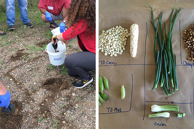
Community science data had previously been collected through the Gardenroots project, which Ramírez-Andreotta directs. Gardenroots engages community members as co-designers in research about the health of their own gardens and residential areas. The team used Gardenroots data about soil, water, and plant concentrations of various carcinogenic and toxic metals as part of the vulnerability data. On the other hand, Gardenroots data about the number of participating communities was used as an indicator of social capital, one of the markers of community resilience.

Community members collect soil (left) and plants (right) for sampling as part of the Gardenroots project. (Photo courtesy of Mónica Ramírez-Andreotta)
The team also used information from 10 government datasets. Data were pulled from sources such as the American Community Survey, the U.S. Department of Agriculture, the U.S. Environmental Protection Agency’s Environmental Justice Screening and Mapping Tool, and the Arizona Department of Health Services. When combining data, the team had to make deliberate decisions about reconciling information from different sources, for example how to combine data that differed in spatial or temporal scales.
Vulnerability datasets included information related to factors that put a community or individual people at higher risk for environmental public health problems. The team included:
- Social attributes (e.g., low income and linguistic isolation)
- Physical and environmental measurements (e.g., ozone levels and proximity to sources of pollution)
- Health measures (e.g., diabetes and cancer rates)
Resilience datasets encompassed factors such as:
- Economic capital (e.g., labor force status)
- Human capital (e.g., health care coverage and internet service)
- Political capital (e.g., number of registered voters)
- Social capital (e.g., access to parks and elementary schools)
Ramírez-Andreotta looks forward to using the integrated data to tackle difficult environmental public health questions and thinks it will be useful to inform public policy.
“Integrated data can help inform decision-making,” said Ramírez-Andreotta. “For example, an understanding of soil quality, which we get from both Gardenroots and U.S. Geological Survey data, can inform local food production efforts and address food deserts. But taking it one step further, if the data show that soils are not suited for crops in a particular area, affected families in those areas can be connected to food assistance programs.”
The team is currently focused on optimizing the integrated data system for use by others in the field and engaging various stakeholders to inform the visual and interactive design requirements and user experience.
“Environmental public health challenges do not respect disciplinary boundaries. Therefore, transdisciplinary research efforts are needed, and we need to successfully share data and the tools that can facilitate those efforts,” said Ramírez-Andreotta. “We do not necessarily need more data, we need to integrate data being generated by all stakeholders, and we want everyone to have access to it.”
Source link
www.niehs.nih.gov


