1. Introduction
Since 1949, China has undergone a profound transformation, notably characterized by a significant surge in population. As of 2020, the population of Chinese has escalated to 1.412 billion, cementing its position as the globe’s most densely populated country. Population increase profoundly affected the allocation of resources [
1], societal framework [
2], and economic progress [
3]. As the population grew, the demand for land resources increased [
4], which has significantly increased our territorial spatial conflicts (TSCs). TSCs are a phenomenon that stems from the differences between different stakeholders over the mode and structure of land use in the process of territorial spatial resource utilization, which in turn triggers spatial competition and conflicts of rights and interests between people and land. A comprehensive analysis of this topic was essential for comprehending and addressing disputes over land resource utilization, and it facilitated the rational allocation and sustainable management of land resources. Existing research results on TSCs are enriched and varied, covering a wide range of aspects such as conflict drivers, measurement methods, and mitigation mechanisms. In terms of research perspectives, while earlier explorations were mostly based on land cover changes in geography [
5], nowadays, there is a greater shift toward research on TSCs (production, living, and ecology) conflicts based on the functional division of territorial spatial conflicts [
6,
7]. In terms of driving factors, natural factors, such as the limited area and suitability of land, as well as human factors arising from the different needs of production, life, and ecology, are the main drivers of territorial spatial conflicts [
8]. In terms of measurement methods, participatory surveys, game theory, the pressure–state–response (PSR) model and its extension model, multi-objective evaluation, and landscape ecological risk assessment are widely used [
9,
10,
11]. These research results provide multidimensional theoretical support and methodological guidance for understanding and resolving territorial spatial conflicts. In this study, the territorial spatial conflicts indicator (SCII) was constructed using a landscape ecological risk model to measure TSCs in terms of external pressure, vulnerability, and stability. Studies showed that the extent of TSCs was affected by a variety of factors, including economic development [
12], land use structure [
13], and changes in social needs [
14]. But fewer researchers have explored the causes of TSCs, and there is a certain lack of academic attention to the causes. Among them, the construction land expansion (CLE) has accelerated the rise in TSCs to a certain extent. For example, some studies have pointed out that the conversion of other land use types to construction land is one of the main causes of territorial spatial conflicts [
9]; others have shown that the increase in construction land space will increase territorial spatial conflicts to a certain extent [
15]. Therefore, the purpose of this paper is to study the relationship between TSCs and CLE and explore how CLE affects TSCs in terms of temporal and spatial changes.
The construction land expansion (CLE), as a distinctive sign of the alteration of various types of land use in the process of urbanization, especially the transfer from cultivated land toward urban construction land [
16], has profoundly affected the land cover and use patterns, the regional variability of this phenomenon intuitively reflected the balanced state of urbanization development. For instance, the swift expansion of construction land in recent years has led to a scattered spatial layout of land [
17], which reduced the efficiency of land use to a certain extent. In order to accurately portray the multidimensional profile of CLE, the research perspective spans the micro levels as well as macro levels [
18,
19]. The macro level focused on the CLE characteristics at the global, national, urban agglomeration, and even individual city levels [
19,
20]. At the micro level, the study examined the process of CLE, covering key indicators such as construction land density and landscape ecology index [
18]. These two levels of cross-scalar research strategy help to reveal the complexity and diversity of CLE. At the same time, researchers used a series of advanced evaluation indexes separately to deeply explore the characteristics of CLE, such as construction land expansion velocity (CEV) [
19,
21], construction land expansion intensity (CEI) [
22,
23], and construction land expansion pattern (CEP) [
24]. Different kinds of methods significantly enrich our considerateness to the dynamics of CLE. However, few studies have combined all these methods to analyze CLE comprehensively and deeply. In addition, the current research on CLE is a multidisciplinary and comprehensive field that requires scientific methods and appropriate scales to assess its wide-ranging impacts and provide scientific support for urban planning and administration. Therefore, this study will comprehensively consider three ways to systematically analyze the spatial and temporal evolution characteristics of CLE in Guizhou Province from a long-term perspective from 1980 to 2020.
However, TSCs, as a key contradiction in the process of land use, have also had a profound and complex chain impact on regional population and economic patterns. In the economic field, TSCs had a positive or negative impact on regional economic growth [
25]. From the population level, TSCs have led to the deterioration of the living environment, the unreasonable layout of public service facilities, and the spatial mismatch of employment opportunities, which will promote the unbalanced migration of the population in the region [
10]. Therefore, it is of great strategic significance to deeply analyze the internal relationship between TSCs and regional GDP and population to optimize the spatial pattern of land and promote regional coordinated development. On this basis, this study constructs the model of economic elasticity coefficient (C
GDP) and population elasticity coefficient (C
POP), and analyzes the collaborative relationship between TSCs and GDP and population in Guizhou Province.
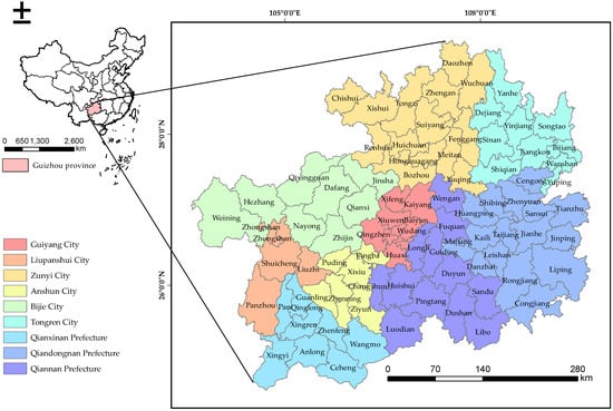
With the acceleration of urbanization and industrialization, there is a sharp contradiction between the expansion of construction land and the protection of cultivated land and ecological construction. The land spatial planning of Guizhou Province points out that all kinds of land use are extremely fragmented, that urban and rural construction space is scattered, and that agricultural and ecological space are intertwined; in addition, problems such as difficult spatial classification management and collaborative governance occur frequently. Therefore, it is necessary to study the relationship between the territorial spatial conflicts and the expansion of construction land in Guizhou, so as to optimize the territorial spatial pattern and promote the coordinated development of regions. In this paper, the correlation between TSCs and CLE was analyzed by using the ordinary least squares (OLS) model and geographically weighted regression (GWR) model. Combining these two methods, it can analyze the complex relationship between TSCs and CLE from macro and micro levels, and provide more scientific and accurate decision support for land and space planning and management. It was expected that this study could provide solid theoretical support for future spatial planning and land use administration in Guizhou Province.
4. Discussion
This paper analyzed the spatial and temporal evolution of TSCs and CLE of Guizhou Province from 1980 to 2020, highlighting the land use challenges encountered during rapid urbanization and economic development. The research revealed that while the velocity and intensity of CLE in Guizhou Province have escalated over time, this expansion displayed considerable geographical variation across various locations. Furthermore, it identified the deficiencies in the existing literature about TSCs and seeks to address this gap by analyzing land use data alongside socio-economic elements in a cohesive manner. This study offered fresh perspectives and insights for future land spatial adjustment and planning by collaboratively analyzing the interaction between territorial spatial disputes and socio-economic issues.
4.1. Main Conclusions
In this study, the TSCs and CLE in Guizhou Province from 1980 to 2020 exhibited dynamic evolution and interrelated characteristics. The CEV and CEI both increased over time, while the CEP exhibited significant variation across different stages, initially dominated by filled and enclave types, and later gradually shifting towards a spread type. This process exacerbated territorial spatial conflicts. The TSCs showed an overall upward trend, with an increasing number of high-conflict areas concentrated in the northwestern part. The relationship between TSCs and CLE demonstrated diverse correlations in various periods, with a weak correlation in the early stages and a significantly enhanced correlation from 2010 to 2020. In terms of causes, the demand for economic development, the acceleration of urbanization, and policy support collectively drove the expansion of construction land. On the other hand, resource constraints, the demand for agricultural development and cultivated land protection, and the need for ecological protection were the primary factors contributing to the increase in territorial spatial conflicts. This study thoroughly analyzed the bidirectional interactive relationship between the two, emphasizing that in the overall territorial spatial system, the irrationality of CLE is the direct cause of TSCs, and at the same time, the existence of TSCs further affected the patterns and paths of CLE. This interactive conclusion provides a more comprehensive theoretical basis for the optimization and conflict coordination of territorial spatial allocation, and also offers a new perspective and line of thinking for subsequent related research. This conclusion is roughly consistent with the existing research conclusions in Jiangsu Province [
29].
4.2. Management Policy Recommendations
This article examined the growth of construction land in Guizhou Province, assessing the changes in territorial spatial conflicts and their relationship with socio-economic factors. Therefore, considering the present situation in Guizhou Province, this study offered the following policy proposals.
- (1)
Optimization of land use structure
The identified trends in construction land expansion indicated a pressing need for a more strategic methodology in land use planning. Policymakers should optimize land use structures to harmonize urban development with environmental preservation. This may entail advocating for vertical development [
38] instead of horizontal expansion where possible, fostering mixed-use developments, and prioritizing brownfield regeneration over greenfield development. This approach can mitigate pressure on land resources and improve land use efficiency.
- (2)
Clearing delineation of ecological and urban boundaries
The escalating territorial spatial conflicts highlighted the necessity of distinctly defining ecological and urban boundaries [
39,
40,
41]. Establishing and maintaining urban growth boundaries can mitigate urban sprawl and safeguard ecologically vulnerable regions. This necessitated a coordinated endeavor to identify and delineate essential ecological areas and to include these in urban planning frameworks.
- (3)
Realizing human-land-coordinated development
The principle of human-land coordination highlighted the amalgamation of social, economic, and environmental goals in land management. Policies must seek to harmonize the demands and ambitions of the populace with the sustainable utilization of land resources. This may encompass community involvement in planning initiatives, investment in public infrastructure that promotes sustainable living, and the formulation of policies that advocate for sustainable agriculture and land management techniques.
- (4)
Reducing regional development gaps
The discrepancies in construction land expansion and territorial spatial conflicts across various regions of Guizhou Province underscore the necessity to rectify regional development imbalances. Policies must focus on underdeveloped regions through strategic investments in infrastructure, education, and technology to foster economic growth and alleviate pressure on land resources. This may also entail the advancement of regional economic collaboration to enable the exchange of resources and expertise.
4.3. Contributions, Restrictions, and Prospective Work
Initially, it leveraged sophisticated geospatial analysis techniques, including Cold Hotspots Analysis, OLS, and GWR, which had rarely been combined in conjunction in prior research. This approach not only assessed the features of construction land expansion while simultaneously examining expansion patterns and the intensity of territorial spatial conflicts, thereby offering a novel perspective on land use changes. This article gathered and examined land use data from 1980 to 2020, enabling the identification of long-term patterns and cyclical variations in construction land expansion and territorial spatial conflicts. This addressed the limitations of prior research that were constrained by shorter data periods and incapable of properly capturing long-term changes. Third, it established a multidimensional indicator system comprising the CEV, CEI, CEP, and SCIIC. These indicators provide dependable instruments for quantitative analysis, augmenting the systematic and scientific character of the investigation. Ultimately, by developing CGDP and CPOP, it connected land use alterations to socio-economic indicators, elucidating the economic motivators and social consequences underlying land use changes, thus offering a more accurate foundation for policy development.
This study provided significant information, although it has limits. The dependence on historical land use data may inadequately reflect the latest alterations in land use patterns, especially during fast urbanization. The study predominantly concentrates on Guizhou Province, perhaps constraining the pertinency of the accumulations to other places with distinct geographical, economic, and cultural circumstances. Future studies should broaden the analysis to encompass more recent data and integrate new variables, including climate change effects, technological innovations, and policy alterations. Longitudinal studies that monitor the progression of land use and disputes over time can offer a more nuanced comprehension of these phenomena. Moreover, comparative analyses with other regions might provide insights into the applicability of the findings and the formulation of context-specific management solutions.
5. Conclusions
This study integrated land use data and diversified socio-economic data from 1980 to 2020 in Guizhou Province, with the help of constructed CLE indicators (CEV, CEI, and CEP) and TSCs, and combined cold hotspot analyses, OLS regression model and GWR regression model to deeply explore the spatio-temporal evolution of the relationship between CLE and TSCs. The study innovatively combined TSCs with socio-economic factors, providing a new perspective and analytical framework for rationally controlling the land space in Guizhou Province. The principal discoveries and contributions were as follows: The CLE in Guizhou from 1980 to 2020 exhibited variations in velocity, intensity, and pattern. The expansion escalated throughout time, predominantly in high-value locations located in the center and southern regions, including Guanshanhu District, Yunyan District, and Panxian County. Moreover, the territorial spatial conflicts in Guizhou Province exhibited temporal and regional variability, with a general upward trend over time. The incidence of high-conflict areas increased from 1980 to 2020, predominantly in the northwest region. The study found that the relationship between construction land expansion and territorial spatial conflicts in Guizhou Province fluctuated over time and across different locations. Between 1980 and 1990, as well as from 2000 to 2010, the correlation was tenuous; nevertheless, it markedly intensified from 2010 to 2020, evidenced by elevated R2 values in GWR analysis.