
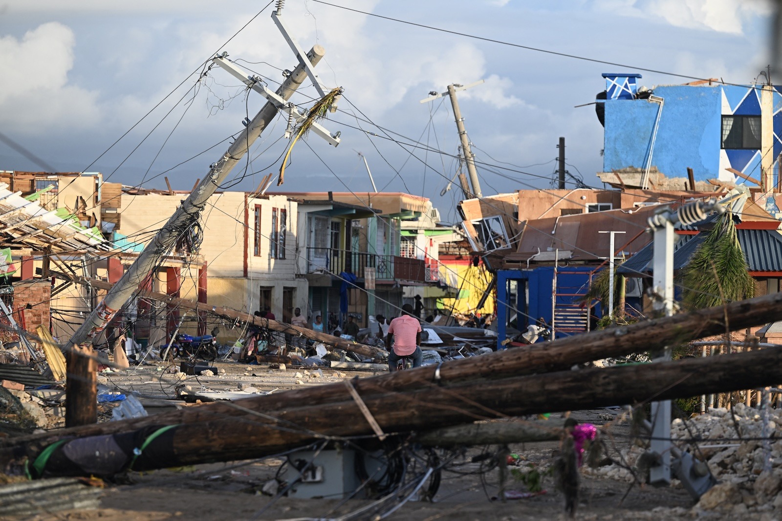
Last month, forecasters watched with dread as Hurricane Melissa lumbered across the Atlantic Ocean, morphed into a monster, and took aim at the islands of the Caribbean. As predicted by the National Hurricane Center, landfall was catastrophic: While officials are still tallying the costs, both in lives lost and property destroyed, at least 67 people were killed across Jamaica, Cuba, Haiti, and the Dominican Republic. AccuWeather estimates $50 billion in damages.
Even before the storm walloped Jamaica and continued its slog north, scientists explained just how climate change helped turn the hurricane into an exceptional Category 5 storm with 185-mph winds: The warm waters it used as fuel were made up to 900 times more likely by global warming, helping bump up those wind speeds by 10 mph.
Secure · Tax deductible · Takes 45 Seconds
Today, the research group World Weather Attribution has crunched the numbers in its own report, similarly finding that human-driven warming increased the tropical cyclone’s maximum wind speeds by 11 mph — a seemingly small amount that can in fact boost damages exponentially — and its extreme rainfall by 16 percent. Overall, this climatic shift increased the likelihood of these conditions by a factor of about six. “This study found all aspects of this event were amplified by climate change, and that we’ll see more of the same as we continue to burn fossil fuels,” said Ben Clarke, a coauthor of the report and a research associate at Imperial College London, during a press call Wednesday.
Gathering that kind of strength requires three main ingredients. For one, these storms love humidity, as dry air discourages their formation. Secondly, they need an atmosphere lacking in vertical wind shear, or winds moving at different speeds and directions at different elevations. And lastly, they need that warm ocean water to transfer energy from the sea to the sky.
Not only did Melissa traverse exceptionally hot waters, it basically crawled over them at relatively slow speed, between 1 and 3 mph, “allowing the storm to gather immense destructive energy,” the report notes. The ocean was also temperate well below the surface, so when the hurricane churned the sea, it drew up more fuel. (Colder conditions in the deep result in upwells that reduce the amount of fuel available. In that case, you can actually see a path of cooler waters left by a storm — a sort of snail trail — like Hurricane Erin did last year.)
What happened in the Caribbean in the days before landfall stunned scientists. A hurricane “rapidly intensifies” when its maximum sustained wind speeds increase by at least 35 mph in a day, and it experiences “extreme rapid intensification” when it jumps 58 mph in that time. Melissa blew well beyond that threshold, doubling from 70 to 140 mph in a mere 18 hours. Indeed, studies have shown that Atlantic hurricanes are now twice as likely to rapidly intensify, and scientists have found an explosion in the number of these events close to shore. This phenomenon is especially dangerous because local officials might be preparing for a tamer tropical cyclone, only to then deal with something much more devastating.
While some infrastructure might survive the wind, there was no escaping another consequence of those gales: the storm surge that came ashore. This raised water levels in Jamaica by up to 16 feet, devastating coastal communities. Here, too, climate change is making things worse, as such a deluge is layering on top of already-higher sea levels. In addition, warmer waters take up more space than colder ones, something known as thermal expansion.
The rainfall, too, was extra catastrophic. The balmier the atmosphere gets, the more moisture it can hold, which is partly why extreme rainfall is getting worse all over the world. In addition, the faster a hurricane’s winds blow — and again, Melissa’s reached 185 mph, which is about as fast as they get — the more water it can wring out of the sky. Indeed, the report notes that heavy five-day rainfall events in Jamaica, like the one associated with Melissa, are about 30 percent more intense and twice as likely in today’s climate. For eastern Cuba, that boost is more like 50 percent.
The landscape itself made matters worse, as Melissa’s extreme rainfall raced down mountains and valleys, accelerating under its own substantial weight. Worse still, it had been raining in Jamaica prior to the storm’s arrival, so the Earth couldn’t soak up more water to help prevent flooding. “The storm’s slow movement meant destructive conditions persisted for many hours, with extreme rainfall, hurricane-force winds, and storm surge sustained over extended periods,” said Jayaka Campbell, a coauthor of the report and climate scientist at the University of the West Indies in Jamaica, during the press call.
Thanks to advances in hurricane science, though, forecasters were able to accurately predict Melissa’s rapid intensification, giving everyone plenty of heads up. That allowed Jamaica to open 881 emergency shelters and pre-positioned supplies, while Cuba evacuated 735,000 people from coastal and low-lying areas.
“If there is a silver lining to the storm, it’s that we’re living in a time where we have good forecasts for hurricanes,” said Roop Singh, head of urban and attribution at the Red Cross Red Crescent Climate Centre and a coauthor of the report, during the call. “It’s likely that this saved many lives. At the same time, it’s important to note that people have no living memory of a storm this strong, which does make it more difficult to adequately prepare.”
Source link
Matt Simon grist.org